
These NCERT Solutions for Class 8 Social Science Part 2 Chapter 1, World Geography: Some Glimpses, cover the opening chapter of Exploring Society: India and Beyond, Part 2 (2026-27 session). The answers run from The Big Questions at the start of the chapter to the Questions and activities at the end and explain why every map projection distorts something, how the oceans help regulate the climate, why coral reefs are called the ‘rainforests of the sea’ and what makes the Tibetan Plateau unique. Check your own answers first, then revise with the world-tour summary, key facts, feature table and FAQs that follow.
On this page:
World Geography: Some Glimpses Class 8 Question Answers (Part 2, Chapter 1)
Class 8 Social Science Part 2 Question Answers of Page 1
Page 1 – The Big Questions
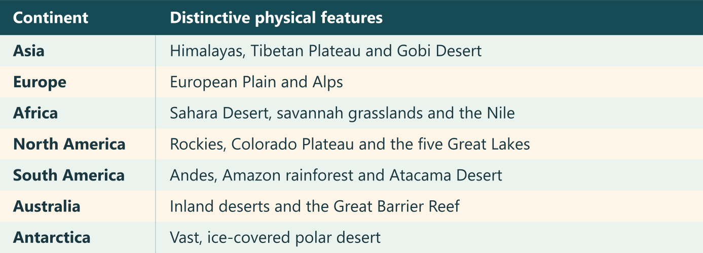
1. What are the unique physical features of the continents?
Answer:
Each continent has some features that stand out:
- Asia has the Himalayas, the high Tibetan Plateau and the cold Gobi Desert.
- Europe has the vast European Plain and the Alps.
- Africa has the hot Sahara Desert, the savannah grasslands and the Nile.
- North America has the Rocky Mountains, the Colorado Plateau and the five Great Lakes.
- South America has the Andes, the Amazon River and its rainforest, and the Atacama Desert.
- Australia has a large desert region inland and the Great Barrier Reef off its north-eastern coast.
- Antarctica is covered in ice and is the world’s largest cold desert.
2. Why do we need to understand world geography?
Answer:
World geography helps me understand how mountains, rivers and seas shape the climate and affect where people live, farm and trade. For example, the southern Indian Ocean affects the monsoon in the Gangetic Plains. The Suez Canal shortens the sea route between India and Europe. Studying these links helps me see how distant places are connected and why natural resources need to be looked after.
3. How do human actions trigger environmental issues?
Answer:
When people clear forests, many plants and animals lose their habitats. Waste from industries and water running off farms can pollute lakes. Overfishing upsets the balance of life on coral reefs, while pollution and climate change can damage corals and lead to bleaching. When corals die, many sea animals lose the food and shelter they depend on.
Class 8 Social Science Part 2 Question Answers of Page 2
Page 2 – LET’S EXPLORE
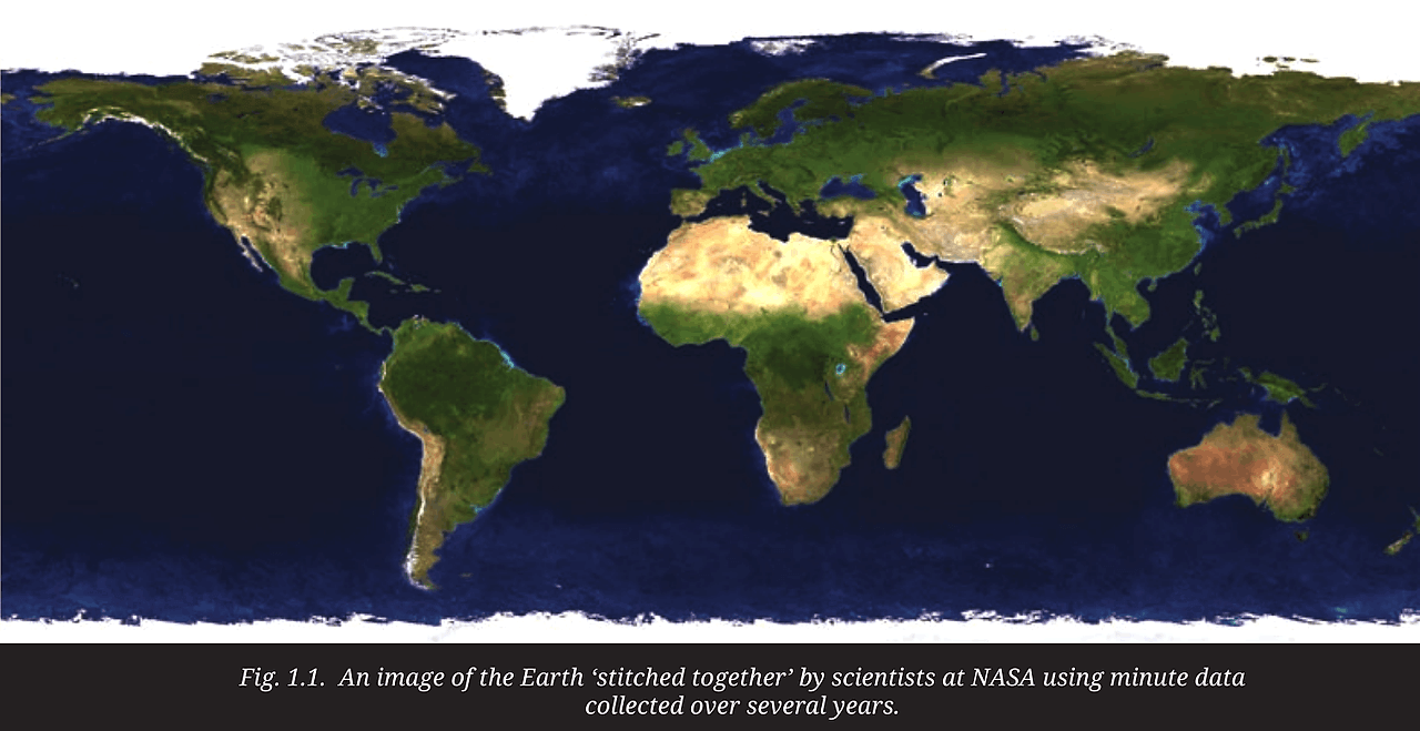
1. What do you think each of the different colours in the map in Fig. 1.1 represents?
Answer:
I can see oceans in blue, pale stretches of desert such as the Sahara and white ice near the poles. The colour key for physical maps helps me read the other features. Blue also shows seas, lakes and rivers. Green shows plains, yellow or brown shows plateaus, and dark brown shows high mountains. Light yellow stands for deserts and white is used for ice and glaciers.
Class 8 Social Science Part 2 Question Answers of Page 11
Page 11 – LET’S EXPLORE
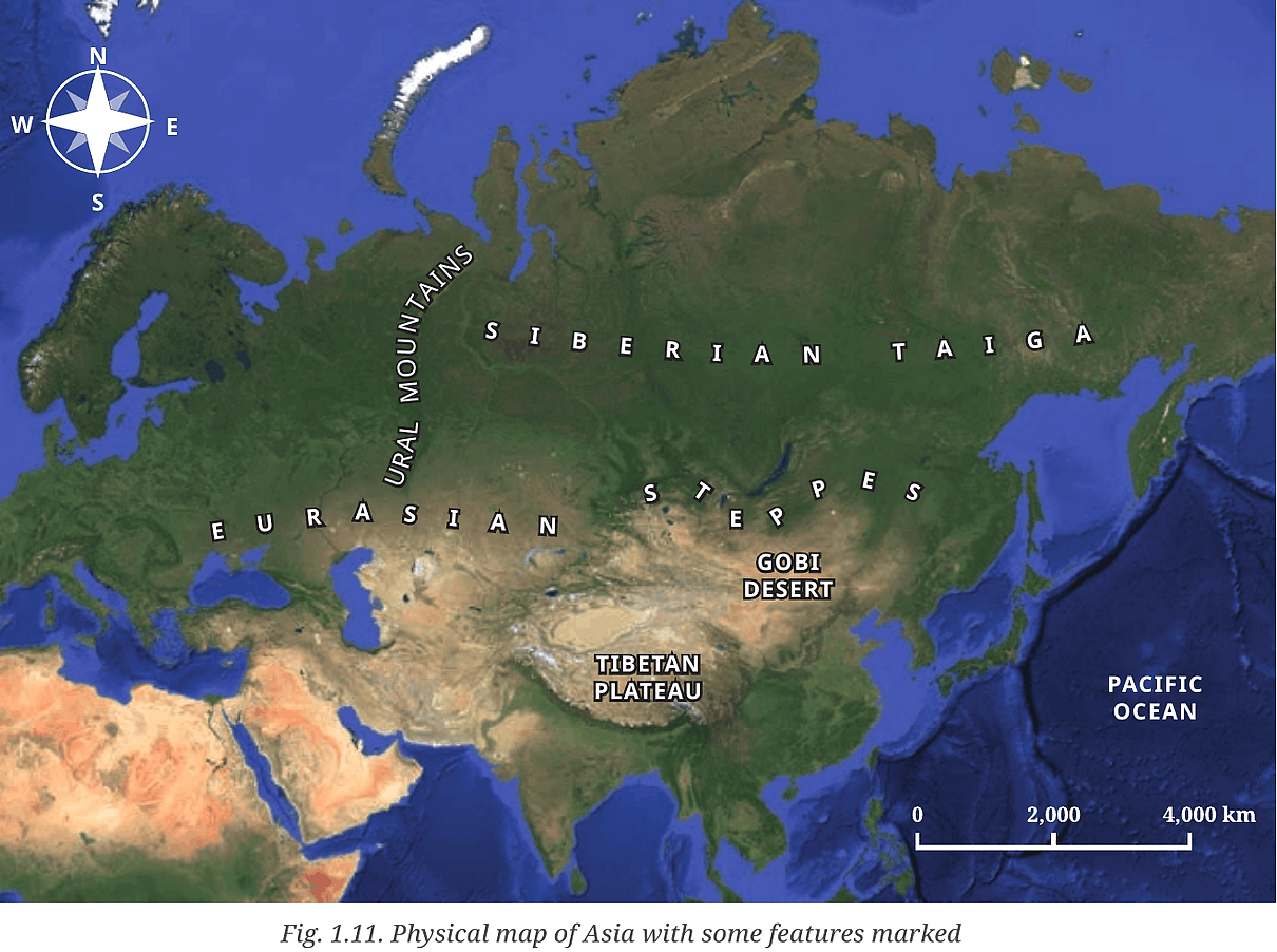
1. Study the map in Fig.1.11. What are the different physical features represented here? (Hint: You may refer to LET’S EXPLORE on page 2 of this chapter.)
Answer:
The Ural Mountains are on the western side of the map. The high Tibetan Plateau lies just north of the Himalayas and the Gobi Desert is to its north-east. The Eurasian Steppes are wide grasslands. Farther north is the Siberian Taiga, a large region of coniferous forests. The Pacific Ocean is shown in blue to the east.
Class 8 Social Science Part 2 Question Answers of Page 15
Page 15 – LET’S EXPLORE
1. Assess and describe the Himalayas from the perspective of these different roles.
Answer:
The Himalayas affect the climate by blocking cold winds from the north and making moist monsoon winds rise and bring rain. They act as a water tower because melting snow and glaciers feed rivers such as the Indus and the Brahmaputra. Different heights have different habitats, from forests on the slopes to cold alpine areas higher up. That helps many kinds of plants and animals live there. The range also forms a natural barrier along the northern part of the Indian subcontinent.
Class 8 Social Science Part 2 Question Answers of Page 18
Page 18 – LET’S EXPLORE
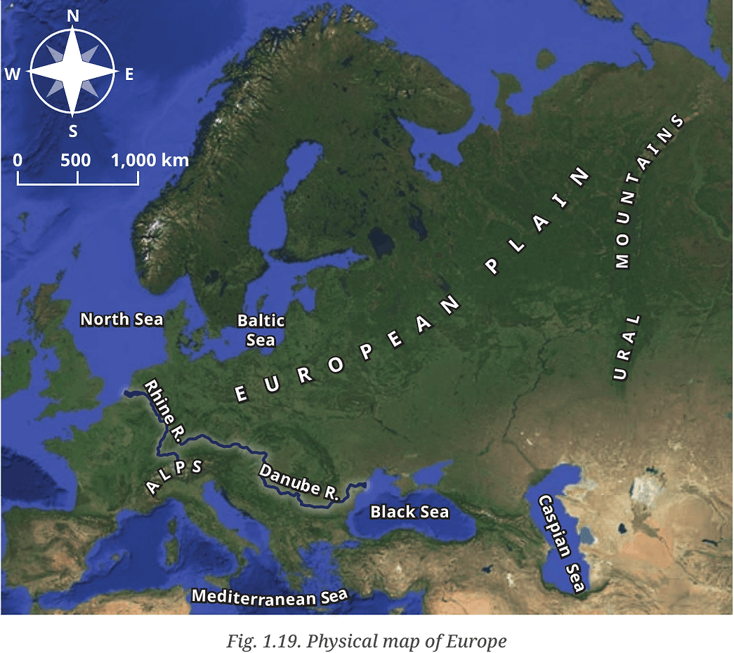
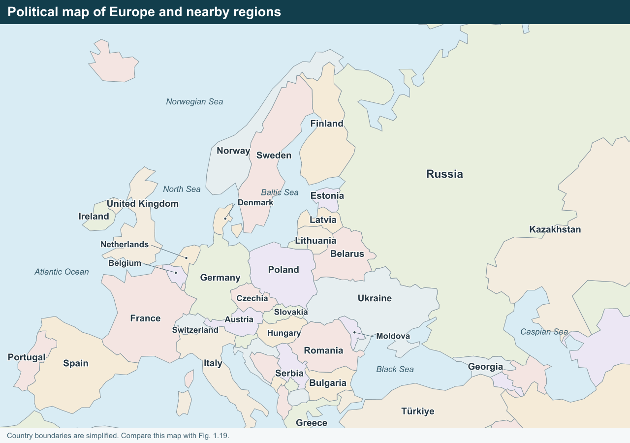
1. Observe the area covered by the European Plain. Now turn to the political map of the world at the end of this textbook. List the countries that are part of the European Plain (you need not memorise them).
Answer:
I traced the plain from northern France eastwards to the Ural Mountains. It covers parts of France, Belgium, the Netherlands, Germany, Denmark and Poland. Farther east it extends across parts of Lithuania, Latvia, Estonia, Belarus, Ukraine and western Russia. The plain crosses country borders and some countries on the list also have hills or mountains.
Class 8 Social Science Part 2 Question Answers of Page 22
Page 22 – LET’S EXPLORE
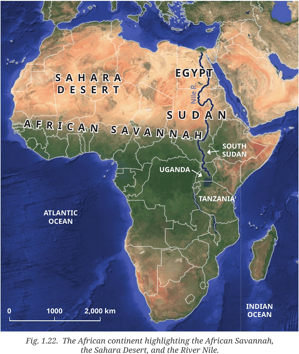
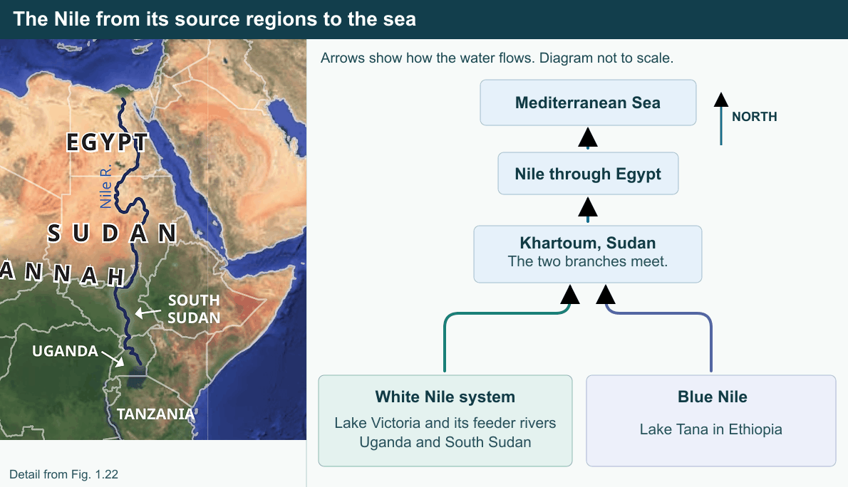
1. On the map (Fig. 1.22) locate the course of the River Nile. Where does it originate from and in which direction does it flow? Turn to the political map at the end of the book, and identify some of the areas that the river flows through.
Answer:
I traced the Nile mainly northwards. One branch, the White Nile, is fed by Lake Victoria and the rivers that flow into it. It passes through Uganda and South Sudan before reaching Sudan. The other branch, the Blue Nile, flows out of Lake Tana in Ethiopia. The two branches meet at Khartoum in Sudan. From there the Nile flows north through Sudan and Egypt and enters the Mediterranean Sea.
Class 8 Social Science Part 2 Question Answers of Page 24
Page 24 – LET’S EXPLORE
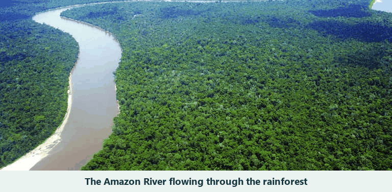
1. The Amazon Rainforest has been called the ‘Lungs of the Earth’. Why do you think this might be so?
Answer:
I think the name comes from the work done by the forest’s many leaves. During photosynthesis, its trees and other plants use sunlight to make food. At the same time, they take in carbon dioxide and release oxygen. The forest also stores carbon in its trees and soil. The nickname helps me remember that a forest this large can affect the air and climate well beyond South America.
2. The countries in this region need land for development but risk losing the Amazon Rainforest. Discuss in groups: What are the short and long-term effects of deforestation, and how can we protect the Amazon for the planet?
Answer:
Our group thought that clearing land could make room for farms or buildings, but animals would start losing shelter and food right away. Without tree roots, heavy rain could also wash away more soil. Over time, some species could disappear from the area and the forest would store less carbon, adding to climate change. Forest communities could also lose resources they depend on. We would use land that has already been cleared where possible, protect the remaining forest with the help of its Indigenous communities, and restore damaged areas with native trees.
Class 8 Social Science Part 2 Question Answers of Page 31
Page 31 – Questions and activities
1. Why do all map projections have some amount of distortion?
Answer:
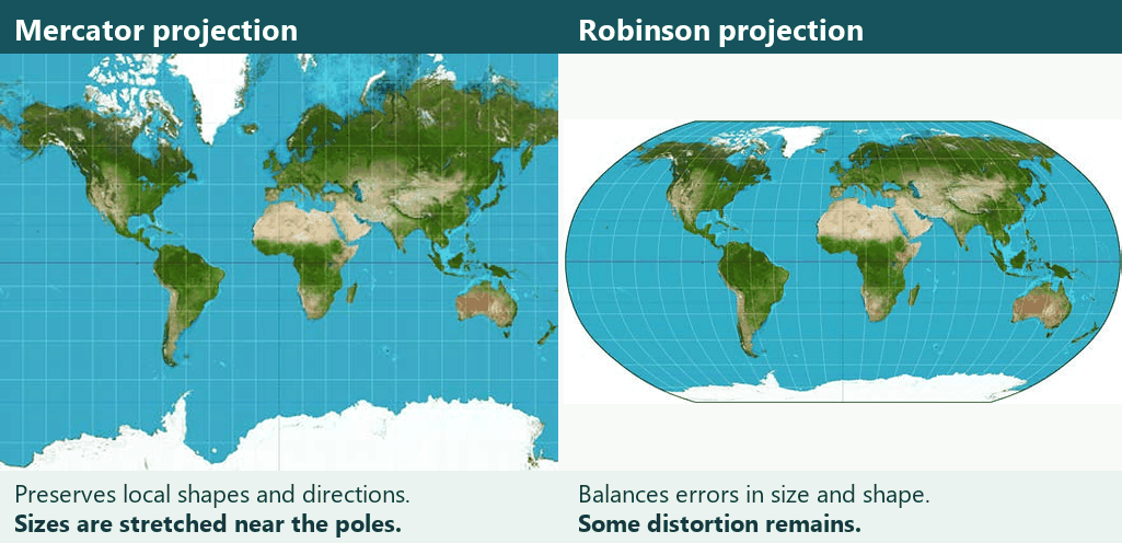
Earth’s surface is curved, but a paper map is flat. I can see the problem by peeling an orange and trying to lay the peel flat. It will stretch, wrinkle or tear. In the same way, a world map cannot keep every area, shape and distance correct at once. The Mercator projection preserves local shapes and directions but makes land near the poles look much larger. The Robinson projection reduces some of the size and shape differences without removing them completely.
2. What makes the Tibetan Plateau unique?
Answer:
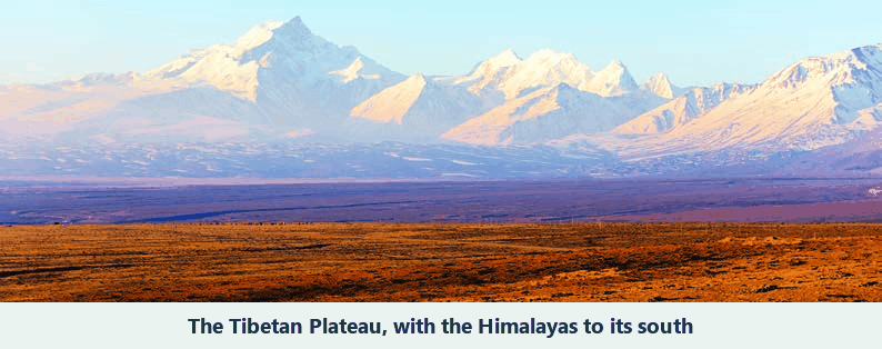
The Tibetan Plateau, north of the Himalayas, is the world’s highest and largest plateau. Its average height is over 4,500 metres above sea level, which helps explain why it is called the ‘Roof of the World’. The collision of two tectonic plates lifted this huge area of land. Its snow and glaciers hold so much freshwater that the region is also called the ‘Third Pole’. Rivers such as the Indus, Brahmaputra and Yangtze begin here, and the plateau influences Asia’s climate.
3. Why are coral reefs called the ‘rainforests of the sea’?
Answer:
Coral reefs are called the ‘rainforests of the sea’ because they are home to so many kinds of living things. Fish, crabs, turtles and sponges find food or shelter among the corals. Reefs support about a quarter of the species in the ocean. Like a rainforest on land, a healthy reef provides many places for different species to live.
4. How do the oceans help to regulate the Earth’s climate?
Answer:
Oceans absorb heat and release it slowly. Currents carry warm water from near the Equator towards the poles and bring cold water back towards warmer regions. This movement changes the climate of nearby coasts. For example, the warm Gulf Stream helps keep the United Kingdom warmer than other places at the same latitude. The oceans also supply moisture to the air, which forms clouds and brings rain.
5. What is the main reason for the Great Barrier Reef facing threats today?
Answer:
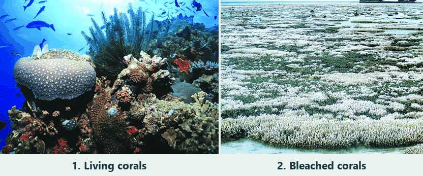
Human activity is the main reason. Climate change warms the ocean, and unusually warm seawater can stress corals and cause them to bleach. If the stress lasts, corals can die. Fish and other sea animals then lose places to feed and shelter. Pollution and overfishing put further pressure on the reef.
6. Why is the Amazon Rainforest often called the ‘Lungs of the Earth’?
Answer:
The name points to how this huge forest affects the air. Its leaves take in carbon dioxide and release oxygen while making food. Its trees and soil also store carbon. Protecting the forest therefore helps keep carbon out of the atmosphere and matters to people far beyond the Amazon basin.
7. Choose two different types of geographical features you have explored in this chapter. Write short paragraphs on how they influence the flora and fauna or human lives in that area. Do they also have an implication for the whole globe?
Answer:
Grasslands – The Eurasian Steppes have wide areas of grass and few trees. Water bodies near them give migrating birds such as the Siberian crane places to rest. The grasses also store carbon below ground. This matters beyond the region because it affects the amount of carbon in the atmosphere.
Rivers – The Nile brings water to otherwise dry areas. It supports crops, fishing and settlements, and provides a route for transport. Its water helped ancient Egyptian civilisation grow. The river’s water is mainly important to the people and wildlife in its basin, but the history it helped shape is part of the world’s heritage.
8. Discuss how oceans influence climate and trade. Use examples from the Indian and Pacific Oceans.
Answer:
The Indian Ocean supplies heat and moisture to the air, and conditions over it affect the monsoon rains in the Gangetic Plains. It also connects trading regions. Ships from India can travel through the Red Sea and the Suez Canal to reach Europe. The Pacific, the largest ocean, stores and moves huge amounts of heat. Its currents bring warm or cold water along different coasts and affect their climate. The Pacific also connects ports on opposite shores, allowing ships to carry goods between Asia and the Americas.
9. Choose one environmental issue (deforestation, reef bleaching, or desertification) and explain its causes, impacts, and possible solutions.
Answer:
I chose coral bleaching. When seawater gets too warm, corals can become stressed and turn pale. Pollution also makes life harder for corals. If the stress continues, some corals die. Fish and other animals then lose places to feed, hide and grow. We can cut greenhouse gas emissions to slow ocean warming, keep waste out of the sea and limit overfishing so that reefs have a better chance to recover.
10. Imagine you are a geographer asked to advise a government about protecting one major landscape in your country. Which one would you choose, and why?
Answer:
I would choose the Indian Himalayas. Their snow and glaciers act like a water tower, feeding rivers that people downstream use. The mountains also support many kinds of plants and animals. I would ask the government to protect forests and freshwater sources, plan construction carefully on steep slopes and manage tourism so that litter stays out of streams. I would involve people who live there because they know the places that need care.
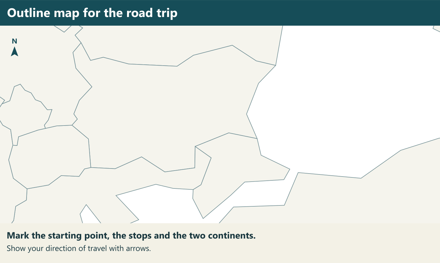
11. Imagine that someone is funding a group of you for a road trip across two continents. There are differences of opinion on which two they should be. Make a pitch for the ones you would like everyone to go to. Use a blank map, trace your route and locate the places on it, and try to convince the others to your point of view. You could use a variety of creative ways.
Answer:
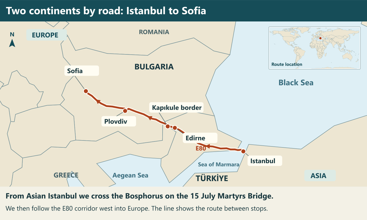
I would vote for Asia and Europe. We could start on the Asian side of Istanbul and drive across the Bosphorus on the 15 July Martyrs Bridge. Imagine being able to point to two continents from the same city! From European Istanbul, we would follow the E80 route past Edirne, cross into Bulgaria at Kapıkule, stop at Plovdiv and finish in Sofia.
At the Bosphorus we would see how a narrow strait separates two shores and how a bridge connects them. In Plovdiv we could sketch the Maritsa River and the surrounding plain. Near Sofia we could compare the flat land with Mount Vitosha. I would ask each group to take one photo or make one sketch at a stop. We could put them together to show how a strait, a river plain and a mountain shape where people live and how they travel.
Class 8 SST Part 2 Ch: 1 Extra Question-Answers for Practice
Very Short Answer Type Questions
1. What is an oblate spheroid?
See AnswerIt is a nearly round shape that bulges at the equator and is slightly flattened at the poles.
2. What does a cartographer do?
See AnswerA cartographer makes maps.
3. About what percentage of Earth’s surface do oceans cover?
See AnswerOceans cover about 71 per cent of Earth’s surface.
4. Which ocean is the largest and deepest?
See AnswerThe Pacific Ocean is the world’s largest and deepest ocean.
5. What shape does an ocean trench usually have in cross-section?
See AnswerAn ocean trench is usually V-shaped in cross-section.
6. What is the deepest part of the Mariana Trench called?
See AnswerIt is called the Challenger Deep.
7. What is a strait? Give one example.
See AnswerA strait is a narrow channel that joins two seas or oceans. The Strait of Malacca is one example.
8. Which is the world’s largest bay?
See AnswerThe Bay of Bengal is the world’s largest bay.
9. Why is Mongolia called the ‘Land of the Eternal Blue Sky’?
See AnswerMongolia gets about eight to nine months of sunny weather.
10. What is a yurt?
See AnswerA yurt is a dwelling used by nomadic people of the Eurasian Steppes.
11. What is permafrost?
See AnswerPermafrost is ground that remains frozen for long periods. It is found in places such as the tundra.
12. Which flower of the Alps is the national flower of Austria?
See AnswerThe edelweiss is the national flower of Austria.
13. How do the large ears of the fennec fox help it in the Sahara?
See AnswerIts large ears help it release body heat and hear prey moving underground.
14. What are the Uyuni Salt Flats, and where are they located?
See AnswerThey are a huge, flat area covered in salt in Bolivia.
15. Where can visitors see the geyser called ‘Old Faithful’?
See AnswerIt erupts at Yellowstone National Park in the Rocky Mountains.
Short Answer Type Questions
1. What makes the Mercator projection useful for navigation, and when is it a poor choice?
See AnswerThe Mercator projection preserves local shapes and directions, which helps sailors plot a route. It stretches areas near the poles, so it is a poor choice for comparing the sizes of places such as Greenland and India.
2. How can a snail find food in the deepest parts of an ocean trench?
See AnswerSunlight cannot reach the deepest parts of a trench. Some bacteria there use energy from chemicals to make their own food. A snail can feed on these bacteria, so this small food chain can survive in darkness.
3. How do bays help ports and dockyards operate?
See AnswerA bay cuts into the land, which partly shelters it from strong winds blowing over the ocean. The calmer water gives ships a safer place to stop and helps ports and dockyards load cargo or repair vessels.
4. How do the wet and dry seasons affect life in the African savannah?
See AnswerRain in the wet season helps grasses grow and fills waterholes. In the dry season, water and fresh grass become harder to find. Animals such as zebras may move in search of places with enough food and water.
5. How do some people in the Sahara use housing design to cope with temperature changes?
See AnswerSome people build dwellings underground, where temperatures change less than they do above the surface. The surrounding earth helps keep these homes cooler in summer and warmer in winter, making them more comfortable during extreme weather.
6. How does vegetation change as you climb higher in the Alps?
See AnswerAt lower elevations in the Alps, we find trees such as oak and beech. Spruce and pine are more common higher up. In the high mountains, alpine flowers such as edelweiss grow in places where many trees cannot.
7. How can dust from Africa help plants grow in South America?
See AnswerWinds carry dust from the Sahara Desert across the Atlantic to the Amazon Rainforest. The dust contains phosphorus, a nutrient that plants need to grow. A dry desert can supply nutrients to a wet forest far away.
8. Why is the Atacama Desert useful both for stargazing and for testing space rovers?
See AnswerThe Atacama Desert has very clear night skies, so observers can see stars and other objects in space well. Its dry, rocky ground resembles the surface of Mars, which makes it useful for testing rovers before space missions.
9. Why have the Great Lakes been important to nearby cities and industries?
See AnswerThe Great Lakes form a chain of large freshwater lakes. Their shipping routes allow merchants and industries to move goods through the region. Cities nearby also draw drinking water from the lakes, so they depend on them every day.
10. Who are the Spinifex people, and what draws visitors to the desert where they live?
See AnswerThe Spinifex are an Indigenous people who have lived in the Australian desert for over 25,000 years. Younger generations help keep their culture alive. Visitors are drawn to the region’s wildlife, landscapes and Indigenous cultural heritage.
Long Answer Type Questions
1. Why can thawing permafrost lead to further warming?
Answer:
In a tundra, much of the soil stays frozen. This frozen ground holds carbon that can be released as gases such as carbon dioxide and methane when the ground thaws. Both gases trap heat in the atmosphere. As the air warms, more permafrost can thaw and release more gases. In this way, a rise in temperature can start a cycle that leads to further warming.
2. How did the return of wolves help restore ecological balance at Yellowstone National Park?
Answer:
Before wolves were brought back, elk grazed heavily in the park, leaving some plants with little chance to grow again. After wolves were reintroduced in 1995, they hunted elk. As elk numbers fell, grazing pressure eased and vegetation had a better chance of recovering. This example shows that a change in the number of predators can affect both the animals they hunt and the plants those animals eat.
3. How did uplift and erosion work together to shape the Colorado Plateau and its canyons?
Answer:
The Colorado Plateau is made mostly of layers of sedimentary rock. Over a long time, movements in Earth’s crust raised these layers. Rivers and weather gradually wore away some of the rock. The Colorado River cut down through the raised layers, forming a deep canyon and exposing bands of rock along its sides. That is how a high plateau and a deep canyon came to exist in the same landscape.
4. Compare how herders make a living in the Gobi and the Sahara.
Answer:
In the Gobi, vegetation is sparse and winters can be very cold. Herders move their animals with the seasons to find pastures where underground water helps grass grow. In the hot Sahara, nomadic groups also depend on livestock, including camels, goats and sheep. Many have combined herding with trade. Both cases show how people move through dry regions to make use of water, grazing land and trading routes.
5. What similarities and differences can you find in the resources and economic activities of the Rockies and the Appalachians?
Answer:
Both mountain ranges support local economies and attract tourists. In the Rockies, resources such as copper, gold and silver support mining, while rivers make hydropower possible. Agriculture also provides work. In the Appalachians, coal, timber and natural gas have long supported industry. Tourism and renewable energy are also growing there. The kinds of work in each range depend partly on the resources available.
World Geography Class 8: Revise the Chapter’s World Tour in Order
The chapter moves from maps to the oceans and then across the continents. Revise it in the same order:
- Maps: every map projection has some distortion. The Mercator projection keeps shape and direction, which helps navigation, but makes Greenland look larger than India, although it is actually smaller.
- Oceans: learn the five oceans and how warm currents carry water from the Equator towards the poles while cold currents flow back. The Mariana Trench, the deepest of all, plunges past 11,000 metres at its Challenger Deep.
- Asia: the Tibetan Plateau, the highest and largest plateau on Earth, the cold Gobi Desert, the Siberian taiga and the Ural Mountains, which run about 2,500 km from the Arctic Ocean to the border of Kazakhstan.
- Europe: the crescent-shaped Alps, about 1,200 km long, with oak and beech forests lower down and spruce and pine higher up.
- Africa: the Sahara, the largest hot desert in the world, the savannah grasslands and the Nile, almost 6,650 km long.
- The Americas: the Andes and the Amazon in South America, and the Rockies, over 4,800 km long, with Yellowstone National Park in North America.
- The Australian continent: the Great Barrier Reef off the north-eastern coast and deserts such as the Great Victoria Desert.
- Finish by testing yourself with the World Geography: Some Glimpses Class 8 MCQs.
Key Facts and Figures from World Geography: Some Glimpses
- Oceans give us almost half the oxygen we breathe, thanks to tiny organisms called plankton.
- The Challenger Deep is more than 2,000 metres deeper than Mount Everest is high.
- Coral reefs provide food and shelter for about one-quarter of all ocean species, which is why they are called the ‘rainforests of the sea’.
- The Great Barrier Reef stretches over a length of 2,000 km and covers about 350,000 square kilometres.
- Scientists call the Tibetan Plateau and its mountains the ‘Third Pole’, as they hold the largest reserves of freshwater outside the polar regions.
- Dust from the Sahara travels all the way to the Amazon rainforest, carrying phosphorus that its plants need.
- The Suez Canal, opened in 1869, links the Red Sea with the Mediterranean and is the shortest sea route from India to Europe.
- Studying another class as well? Browse our NCERT Solutions for other classes.
World Geography Class 8: Feature, Location and Why It Matters
| Feature | Location | Why it matters |
|---|---|---|
| Mariana Trench | Pacific Ocean | The deepest ocean trench; its Challenger Deep lies over 11,000 m below sea level |
| Great Barrier Reef | Off Australia’s north-eastern coast | A reef system about 2,000 km long, home to a great variety of sea life |
| Tibetan Plateau | North of the Himalayas | The highest and largest plateau on Earth, called the ‘Third Pole’ |
| Sahara Desert | Northern Africa | The largest hot desert in the world |
| Amazon River and rainforest | South America | The world’s largest river by volume, and a rainforest called the ‘Lungs of the Earth’ |
| Rocky Mountains | North America | A range over 4,800 km long, home to Yellowstone National Park |
| Suez Canal | Between the Red Sea and the Mediterranean | Opened in 1869; gives ships the quickest sea link between India and Europe |
Solutions for the other chapters of Part 1 and Part 2 are on our NCERT Solutions for Class 8 Social Science page.
FAQs on Class 8 SST Part 2 Chapter 1
What is Class 8 Social Science Part 2 Chapter 1 about?
It is a quick tour of the Earth’s physical features. The chapter begins with the difficulty of mapping a round Earth, moves to the oceans, ocean trenches, coral reefs and smaller water bodies, and then visits each continent, from Asia to the Australian continent. It ends by showing how human actions such as deforestation and the overuse of resources cause problems like desertification and loss of biodiversity.
How many oceans and continents does the chapter describe?
It names five oceans: the Indian, Pacific, Arctic, Atlantic and Southern Oceans. For land, it uses the most common count of seven continents, namely Africa, Antarctica, Asia, Australia, Europe, North America and South America, and then tours Asia, Europe, Africa, the two Americas and the Australian continent.
Which is the longest river in the world, and which carries the most water?
The chapter names the Nile in Africa, almost 6,650 km long, as the longest river in the world; its basin was the cradle of ancient Egyptian civilisation. The Amazon in South America, fed by the Andes, is the world’s largest river by volume.
What is the difference between hot and cold deserts?
All deserts are dry expanses with very little precipitation and each has its own unique plants and animals. What sets them apart is temperature: the Sahara in Africa and the Thar in the north-west of the Indian subcontinent are hot deserts, while the Gobi in Asia is a cold one.
Who lives in the Amazon rainforest and what threatens it?
Almost 400 indigenous communities live in the Amazon rainforest and play an important role in conserving it. Today the forest is threatened by deforestation and climate change. A rainforest, as the chapter defines it, is an area of tall, mostly evergreen trees that receives a lot of rain.
Why do some websites call this chapter Class 8 Social Science Chapter 8?
Some sites number the two parts of the book together, so the seven chapters of Part 1 are followed by World Geography: Some Glimpses as Chapter 8. In the NCERT textbook it is Chapter 1 of Part 2 and these solutions follow the book’s numbering.