



by Tiwari Academy Team
NCERT Solutions for Class 9 Social Science Part 2 Chapter 1 Oceans and Life – help students understand how the oceans shape our lives. The chapter explains submarine relief features such as the continental shelf, trenches and seamounts and how waves, tides and currents influence climate, fishing and navigation. Students also learn about cyclone and tsunami early warning systems, marine resources, the Blue Economy and maritime zones defined under UNCLOS. These solutions answer all textbook questions in simple language, helping you revise key concepts and prepare well for CBSE 2026-27 exams.
NCERT Class 9 Social Science Part 2 Chapter 1 Solutions
Class 9 Social Science Part 2 Chapter 1 Question Answer
Page 1 – The Big Questions
1. What is the importance of ocean relief?
Answer:
Ocean relief means the varied landforms on the ocean floor, such as continental shelves, plains, ridges and trenches. These features provide different habitats for marine life and influence currents and nutrient movement. Shallow shelves support fishing and contain oil and natural gas. Knowledge of ocean depth and relief also helps safe navigation, laying undersea cables and underwater exploration.
2. How does ocean water movement impact life and environment?
Answer:
Waves shape coasts through erosion and deposition. Tides regularly change coastal water levels, helping fishing, navigation and in suitable places, electricity generation. Ocean currents redistribute heat and nutrients, influencing coastal climate and marine food chains. These movements support livelihoods, but strong waves and currents can also endanger people and damage coastal areas.
3. Why are maritime zones important for a country?
Answer:
Maritime zones define a country’s rights and responsibilities at sea. They help it protect its coast, regulate certain activities and manage resources such as fish, oil and gas. They also distinguish territorial waters from the Exclusive Economic Zone and the high seas. Clear rules support navigation, international cooperation and peaceful settlement of disputes.
4. How can we use ocean resources in a sustainable way?
Answer:
We can regulate fishing, avoid catching young fish, protect breeding grounds and conserve coral reefs and other habitats. We should reduce plastic waste, treat sewage and prevent pollution from ships and industries. Responsible tourism, suitable renewable ocean energy and cooperation between countries can support livelihoods while protecting marine ecosystems for future generations. This approach is central to the Blue Economy.
5. How do early warning systems help protect people from tsunamis and cyclones?
Answer:
Early warning systems continuously monitor earthquakes, sea-level changes and weather conditions. Scientists analyse the data and issue alerts through authorities, phones, satellites and other communication networks. Timely warnings allow people to leave dangerous coastal areas and reach safe shelters. Training, evacuation plans and public awareness are essential because a warning saves lives only when people understand it and act promptly.
Class 9 Social Science Part 2 Chapter 1 Exercises Question Answer
Page 20 – Questions and activities
1. How do different features of the ocean floor affect human activities such as fishing, transport, and underwater exploration?
Answer:
- Fishing: Shallow continental shelves receive sunlight and support abundant marine life, making many of them productive fishing areas. Seamounts can also concentrate nutrients and fish.
- Transport: Knowledge of seabed depth helps ships avoid shallow banks and reefs and enter harbours safely. Charts are especially important for large ships with deep draughts.
- Exploration: Shelves contain oil and natural gas. Deep plains, ridges and trenches are studied for minerals, plate movements and unusual life forms. Great depth, darkness and pressure make such exploration difficult and expensive.
2. How do waves, tides, and ocean currents influence climate, marine life, and human activities around the world?
Answer:
Waves erode coasts, move sediments and build beaches, affecting coastal habitats and tourism. Tides expose and submerge shores, influence feeding conditions and help fishers plan their work. High tides can aid navigation and tidal movement can generate electricity. Ocean currents carry heat and nutrients over long distances, influencing coastal climate and fish populations. Where warm and cold currents meet, nutrient-rich conditions often support important fishing grounds. Strong waves and currents can also threaten boats, coastal settlements and infrastructure.
3. Describe the importance of marine resources.
Answer:
Marine resources are important in several ways:
- Food: Fish and other seafood provide protein and support food security.
- Livelihoods: Fishing, aquaculture, shipping and tourism provide income and employment.
- Energy and materials: Oceans supply oil, natural gas, minerals, sand and gravel, as well as opportunities for tidal, wave and offshore wind energy.
- Environment: Marine ecosystems support biodiversity and help regulate climate.
- Culture and trade: Seas connect countries and shape coastal traditions; conch shells and cowries are examples of their cultural significance.
These resources must be managed responsibly to protect ecosystems and future livelihoods.
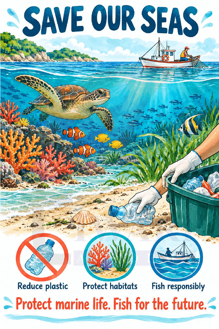
4. Draw a poster that encourages people to protect marine resources. Include a slogan (like Save Our Seas or Fish for the Future) and explain your message in 2–3 sentences.
Answer:
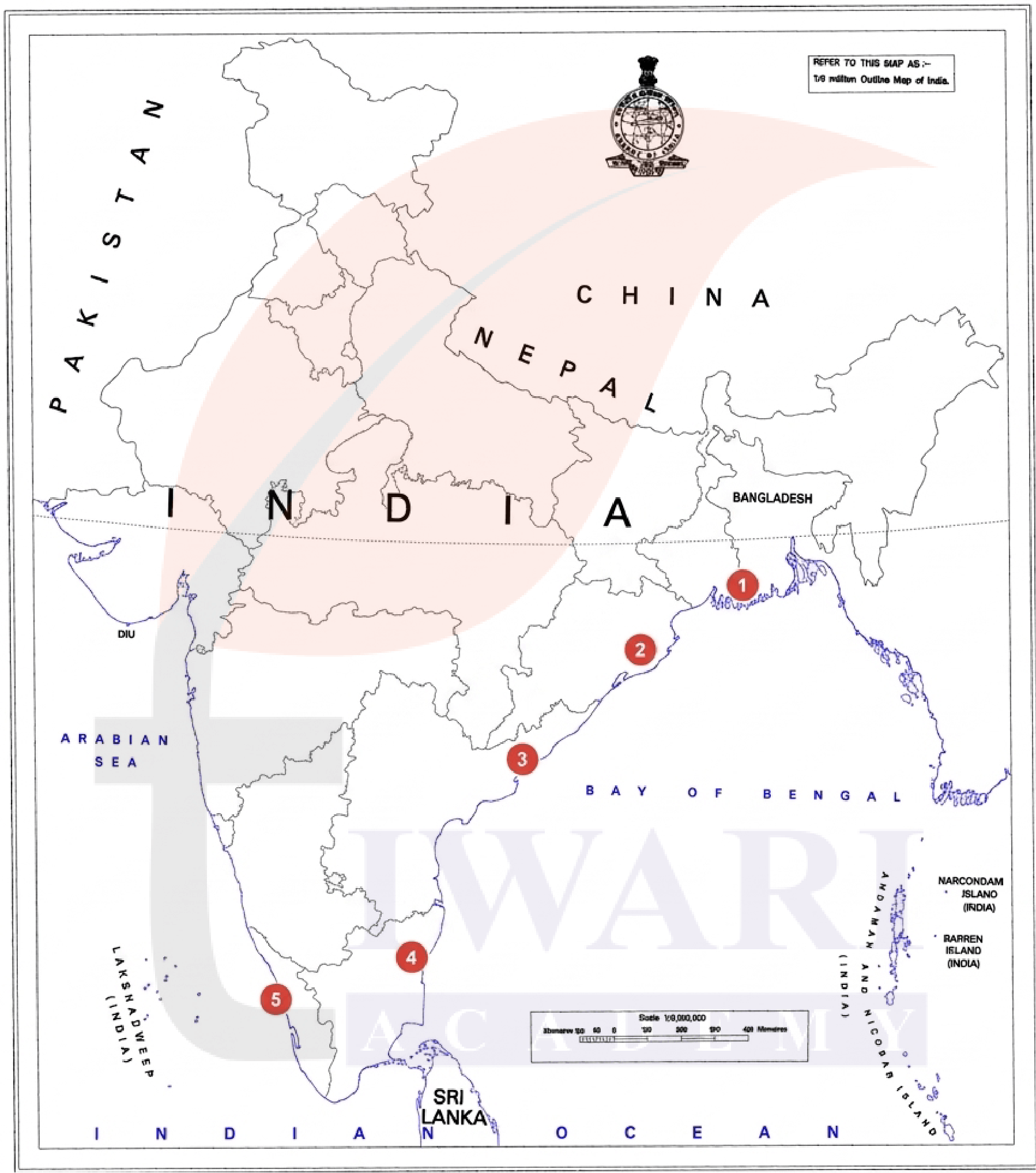
5. Using a map of India, mark at least five coastal states that might need tsunami warnings.
Answer:
Mark these five states:
- West Bengal
- Odisha
- Andhra Pradesh
- Tamil Nadu
- Kerala (Keralam)
All have coastal areas that may need warnings depending on the tsunami’s source and direction. The first four border the Bay of Bengal; Kerala borders the Arabian Sea.
6. Work in a group and act out what would happen when a cyclone warning is issued. Highlight what role different people, like scientists, officials, and coastal villagers, would play.
Answer:
Group role-play:
- Narrator: “Weather observations show a cyclone approaching the coast. Everyone must act before conditions become dangerous”.
- Scientist: “Our observations indicate strong winds, heavy rain and possible coastal flooding. We are sending the forecast and warning to the authorities”.
- District official: “We will share the warning through phones and loudspeakers. Evacuate the identified low-lying areas to the designated cyclone shelter”.
- Fisher: “We will follow marine warnings and avoid going to sea. We will secure equipment only while it is safe”.
- Volunteer: “I will help children, older people and people with disabilities reach the shelter and inform the response team of anyone needing assistance”.
- Villager: “Our family will take its emergency bag, follow the evacuation route and stay at the shelter until the official all-clear”.
- Narrator: “Accurate forecasts, clear communication and timely community action reduce the loss of life”.
7. Suppose a foreign ship is sailing through India’s territorial sea. What principle allows the ship to pass through these waters, subject to certain conditions?
Answer:
The principle is the right of innocent passage. A foreign ship may pass through territorial waters as long as it does not threaten the coastal country’s peace, good order or security. Passage should be continuous and expeditious; stopping is allowed in limited circumstances, such as distress. Fishing, weapons exercises and other activities inconsistent with innocent passage are not permitted under this right.
8. A country has an Exclusive Economic Zone (EEZ) extending up to 200 nautical miles from its baseline. What rights does the country have over natural resources in this zone?
Answer:
The coastal country has sovereign rights to explore, exploit, conserve and manage the natural resources of the waters, seabed and subsoil in its EEZ. These include fish, oil and natural gas, as well as energy from water, currents and winds. It can regulate resource use and protect the marine environment within the relevant legal framework. These are special resource rights, not complete ownership of the sea; other countries retain lawful navigation and related freedoms.
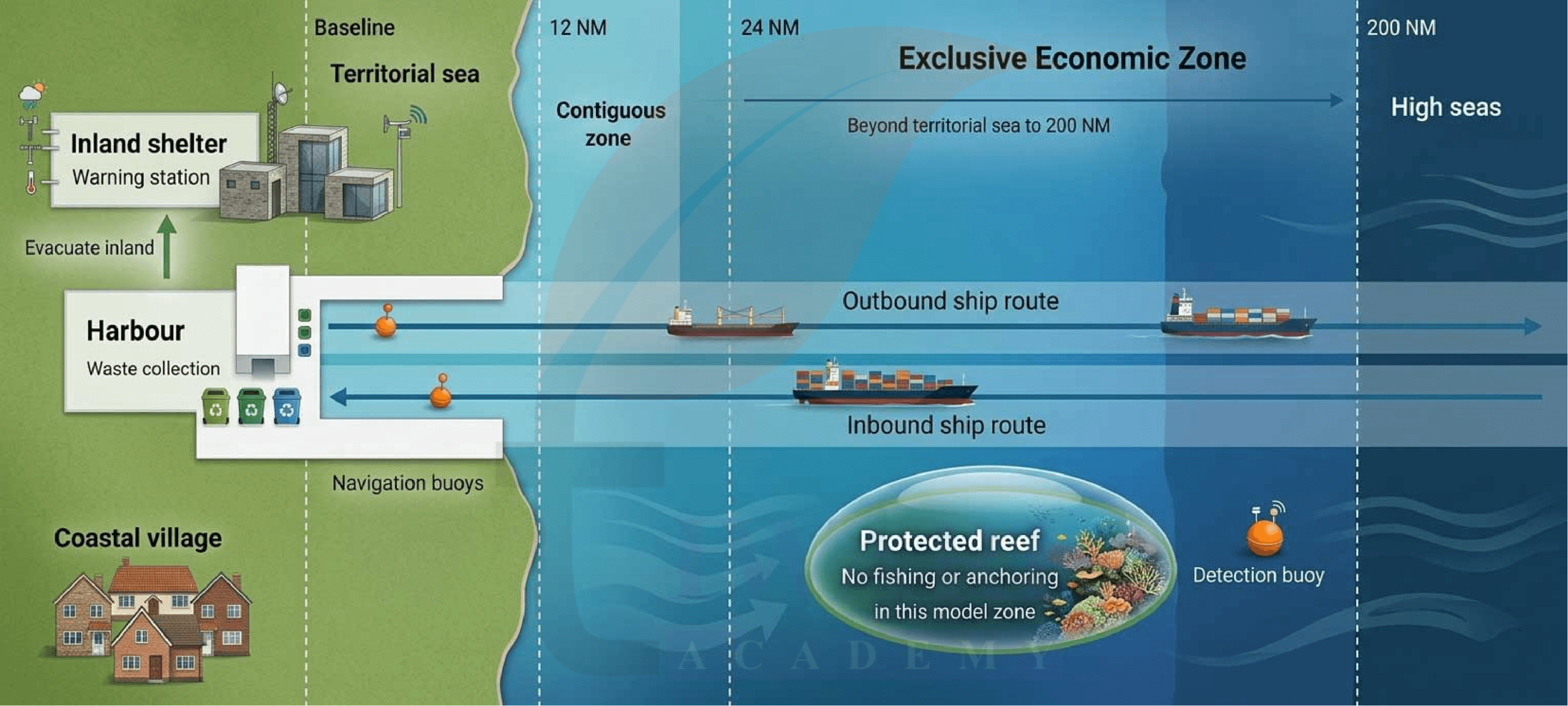
9. Create a model of an ocean with ship routes, protected zones, and safety measures. Based on the model, explain how it follows maritime laws and protects the ocean.
Answer:
Explanation:
Ships follow marked routes, keep a lookout and use a safe speed to reduce collision risks, reflecting COLREGs. Waste facilities and a no-dumping rule reflect MARPOL’s aim of preventing ship pollution. Clearly marked maritime limits show the different rights under UNCLOS. The protected area conserves habitats, while warnings and evacuation arrangements improve coastal safety.
Extra Question Answers for Exam Preparation
Class 9 Social Science Part 2 Chapter 1 Very Short Answer Type Questions with Explanation.
Very Short Answer Type Questions
- A submarine leaves a shallow continental shelf and begins descending a steep underwater surface. Which feature is it crossing?
Answer:
The continental slope descends steeply from the continental shelf towards deeper water, marking the continent’s submerged outer edge. - An underwater mountain has a flat summit. Identify it and explain briefly how its top became flat.
Answer:
It is a guyot, whose summit was flattened by erosion near sea level before becoming submerged. - A student measures the horizontal distance between two neighbouring wave crests. What measurement is being taken?
Answer:
The student is measuring wavelength, the horizontal distance between two successive crests or two successive troughs. - How does hydraulic action enlarge a crack in a coastal rock?
Answer:
Moving water forces its way into rock cracks, loosening and removing material; this erosional process is hydraulic action. - A student says that spring tides occur only during spring. Why is this statement incorrect?
Answer:
Spring tides depend on the alignment of the Sun, Earth and Moon, rather than on a particular season. - A fisher notices that seawater is receding from the shore as the tide falls. Name this phase of the tide.
Answer:
This is the ebb tide, during which seawater moves away from the shore and the coastal water level falls. - In which direction does Earth’s rotation deflect moving ocean water in each hemisphere?
Answer:
The Coriolis effect deflects moving water rightwards in the Northern Hemisphere and leftwards in the Southern Hemisphere. - Why can the direction of a surface current near India change between seasons?
Answer:
Monsoon winds change direction seasonally, causing many surface currents in the northern Indian Ocean to reverse their direction. - Which field of study helps scientists map underwater depths and landforms?
Answer:
Bathymetry studies and maps underwater topography, providing information about water depths and the shape of the seabed. - How does a GEMINI device pass the satellite information it receives to a fisher’s mobile phone?
Answer:
GEMINI transfers received satellite information through Bluetooth to the mobile phone, where an application displays marine advisories and warnings. - Why can the meeting of warm and cold currents attract fishing boats?
Answer:
Mixing waters can provide abundant nutrients, supporting marine food chains and creating productive fishing grounds for coastal communities. - Classify seaweed and offshore natural gas as living or non-living marine resources.
Answer:
Seaweed is a living marine resource because it is an organism; offshore natural gas is a non-living resource. - Which Sustainable Development Goal would a school’s campaign against ocean pollution support?
Answer:
It would support SDG 14, Life Below Water, which promotes ocean conservation and the sustainable use of marine resources. - Is the contiguous-zone limit measured 24 nautical miles beyond the territorial sea? Give the correct starting point.
Answer:
No. Its outer limit is measured up to 24 nautical miles from the baseline, not from the territorial-sea boundary. - What is meant by the flag state of a ship?
Answer:
The flag state is the country where a ship is registered, whose laws generally govern it on the high seas.
Class 9 Social Science Part 2 Chapter 1 Short Answer Type Questions with Explanation.
Short Answer Type Questions
- How can Mauna Kea be described as taller than Mount Everest without being higher above sea level?
Answer:
Mauna Kea’s height can be measured from its base on the ocean floor, much of which lies underwater. Mount Everest rises higher above sea level. The comparison changes because different starting points are used. - A sea arch collapses during a storm. What coastal features may remain immediately and after further erosion?
Answer:
When the roof of a sea arch collapses, an isolated pillar called a sea stack may remain. Continued wave erosion and weathering gradually wear it down, eventually leaving a shorter feature called a stump. - Why should a harbour manager consult a tide table before allowing a large cargo ship to enter?
Answer:
A large cargo ship needs sufficient water beneath its hull. Tide tables help the manager identify suitable water levels for entry. Entering at an appropriate tide reduces the risk of grounding in shallow channels. - Two coastal towns lie at similar latitudes, but one faces a warm current and the other a cold current. How might their temperatures differ?
Answer:
The town beside the warm current may have warmer coastal conditions because the current transfers heat from warmer regions. The town beside the cold current may be cooler, although winds and other geographical factors also influence temperature. - Why do scientists use both seismic observations and measurements of sea-level changes when assessing a possible tsunami?
Answer:
Seismic observations identify an undersea earthquake, but not every earthquake generates a tsunami. Ocean pressure measurements and tide gauges help confirm and track water disturbances, improving assessments of the threat and the warnings issued. - How does giving cyclones distinct names make disaster communication easier?
Answer:
Distinct names help scientists, officials and the public identify a particular cyclone without confusing it with another storm. This makes forecasts, warnings, news reports and discussions easier to understand and share during emergency preparations. - A school receives disaster warnings quickly but has never practised evacuation. What important weakness remains?
Answer:
Students and staff may not know the safest routes, assembly points or their responsibilities. Regular drills help them understand warnings, practise an orderly response and identify anyone needing assistance before a real emergency occurs. - Why is replacing unrestricted fishing with regulated fishing an example of the Blue Economy?
Answer:
Regulated fishing allows communities to earn income while preventing excessive catches and protecting breeding populations. By balancing present livelihoods with healthy marine ecosystems, it helps maintain fish stocks and fishing opportunities for future generations. - A foreign ship claims innocent passage but starts fishing in territorial waters without permission. Is its claim justified? Explain.
Answer:
No. Innocent passage permits peaceful transit through territorial waters, subject to conditions. It does not give a foreign vessel permission to fish there. Unauthorised fishing is inconsistent with the conditions governing innocent passage. - Which agreements address a ship’s collision risk and its pollution, respectively? State how their purposes differ.
Answer:
COLREGs address collision prevention through rules on lookout, speed, signals and vessel movement. MARPOL addresses pollution from ships. The first supports safe navigation, while the second helps protect the marine environment from ship waste and discharges.
Class 9 Social Science Part 2 Chapter 1 Long Answer Type Questions with Explanation.
Long Answer Type Questions
1. A research team plans one expedition to a continental shelf and another to a deep ocean trench. Compare what the team may study and the difficulties it may face.
Answer:
On the continental shelf, the team may study fish habitats, marine plants and resources such as oil and natural gas. Shallow water and greater sunlight make many observations easier. In a trench, the team may investigate deep-sea organisms, rocks and plate movements. Great depth brings darkness, cold conditions and high pressure, requiring specialised equipment. Comparing the two areas would show how ocean relief creates different habitats and influences the methods used for underwater exploration.
2. A company proposes a seaside resort beside a coral reef. Suggest conditions that would allow tourism to benefit the community while protecting marine resources.
Answer:
The resort should treat wastewater, prevent litter from entering the sea and reduce disposable plastics. Boats and visitors should avoid damaging coral through anchoring, trampling or collecting organisms. Construction should protect sensitive coastal habitats. Employing local people and buying responsibly sourced local products would support livelihoods. Visitor education and regular environmental monitoring would encourage responsible behaviour. These conditions connect tourism income with conservation, reflecting the Blue Economy’s aim of improving livelihoods while maintaining healthy marine ecosystems.
3. During a coastal school trip, students feel strong shaking and later notice the sea retreating unusually far. Explain the danger and the group’s immediate response.
Answer:
Strong shaking followed by unusual sea retreat can be a natural tsunami warning. During shaking, students should drop, cover and hold on where possible. As soon as movement is safe, the group should follow its evacuation plan towards higher ground or farther inland. It should not approach the exposed seabed or wait for a phone alert. Teachers should keep students together, assist anyone needing help and follow official updates. Everyone should remain outside the danger area until authorities declare it safe.
4. A student argues that a country can ban every foreign ship from its EEZ because it owns all the water there. Correct this argument and distinguish the EEZ from the territorial sea.
Answer:
The argument confuses resource rights with complete sovereignty. In its EEZ, extending beyond the territorial sea to a maximum of 200 nautical miles from the baseline, a coastal country has special rights to explore, use, conserve and manage natural resources. Other countries retain lawful navigation freedoms there. The territorial sea extends up to 12 nautical miles from the baseline and is under coastal-state sovereignty, subject to innocent passage. Therefore, the EEZ does not give a country unlimited ownership or control over all passing ships.
5. A fishing village notices beach erosion, changing daily water levels and seasonal changes in surface-water flow. Identify the three ocean processes and suggest how the village can plan around them.
Answer:
Beach erosion is mainly linked to wave action, daily water-level changes to tides, and seasonal surface-water flow to ocean currents influenced by changing winds. The village can monitor shoreline changes and avoid placing new structures on eroding shore edges. Fishers can use tide tables to plan boat movements and consult current and weather advisories before sailing. Protecting coastal habitats and maintaining clear evacuation routes would strengthen preparedness. Understanding these different processes helps the community manage livelihoods and reduce avoidable risks.