



by Tiwari Academy Team
Class 9 Social Science Chapter 2 Shaping of the Earth’s Surface NCERT Solutions – Question Answers and Extra Practice questions for 2026-27 Exams. Chapter 2 of Class 9 Social Science – Shaping of the Earth’s Surface – explores the powerful forces that continuously reshape our planet. The chapter begins with the theory of plate tectonics, explaining how the Earth’s crust is broken into moving tectonic plates that give rise to mountains, volcanoes and earthquakes.
It then examines how weathering and erosion, along with natural agents like running water, glaciers, wind, waves and underground water, carve out diverse landforms such as deltas, meanders, dunes and caves. The chapter also highlights how these landforms are deeply connected to human life and discusses disasters like landslides, avalanches, GLOFs and dust storms that arise from them.
Quick Links:
- Chapter’s Question Answers
- Exercises Question Answers
- Very Short Answer Type Questions
- Short Answer Type Questions
- Long Answer Type Questions
Download Class 9 Social Science App to study Class 9 Social Science Offline.
NCERT Class 9 Social Science Chapter 2 Solutions
Class 9 Social Science Chapter 2 Question Answer
Page 16 – Let’s Explore
Examine the plate map (Fig. 2.3) with the earthquake and volcano map (Fig. 2.4) What correlation do you observe?

Answer:
When we compare the plate map (above) with the earthquake and volcano map (below), we can clearly observe that most earthquakes and volcanoes are concentrated along the edges of tectonic plates, i.e., plate boundaries. The maximum concentration is seen around the Pacific Ocean, forming a belt known as the Ring of Fire. This proves that plate movement is the main cause of earthquakes and volcanic activity. Where plates collide, pull apart or slide past each other, the Earth’s crust becomes unstable, releasing energy in the form of earthquakes or magma in the form of volcanoes.
Page 17 – Let’s Explore
Observe the map showing the distribution of earthquakes and volcanoes (Fig. 2.4). Can you identify which continents and countries are located around the Ring of Fire with the help of an atlas or a globe?

Answer:
Countries and continents located around the Ring of Fire include:
- Americas: USA (especially California and Alaska), Mexico, Chile, Peru, Colombia
- Asia: Japan, Philippines, Indonesia, Taiwan, Russia (Kamchatka Peninsula)
- Oceania: New Zealand, Papua New Guinea
These regions lie along the boundaries of the Pacific Plate and surrounding plates, making them highly prone to earthquakes and volcanic eruptions.
Page 17 – Let’s Explore
Does India have a risk of earthquakes?
India has experienced some major earthquakes in the past, resulting in thousands of deaths. A large earthquake in a densely populated country like India can cause serve damage to life and environment. Can you find out which region is more vulnerable to earthquakes? Why do you think human lives are at risk?

Answer:
Yes, India does have a significant risk of earthquakes. India sits on the Indo-Australian Plate, which is constantly moving northward and colliding with the Eurasian Plate. This collision is what formed the Himalayas and continues to create seismic stress.
- The regions most vulnerable to earthquakes in India are:
- The Himalayan belt (Jammu & Kashmir, Himachal Pradesh, Uttarakhand, Northeast India)
- The Andaman & Nicobar Islands
- Parts of Gujarat (as seen in the devastating 2001 Bhuj earthquake)
- The Deccan Plateau also has some seismic risk
Human lives are at risk because India is densely populated. When earthquakes strike urban or rural areas, poorly constructed buildings collapse, communication lines are cut and rescue becomes difficult. The 2001 Gujarat earthquake killed over 20,000 people, which is a clear example of how deadly earthquakes can be in densely populated regions.
Page 18 – Let’s Explore
Look carefully at this photograph and answer the following questions:
→ What do you think caused this situation?
→ What could that grey powder be?
→ What does it tell us about the Earth’s internal forces?
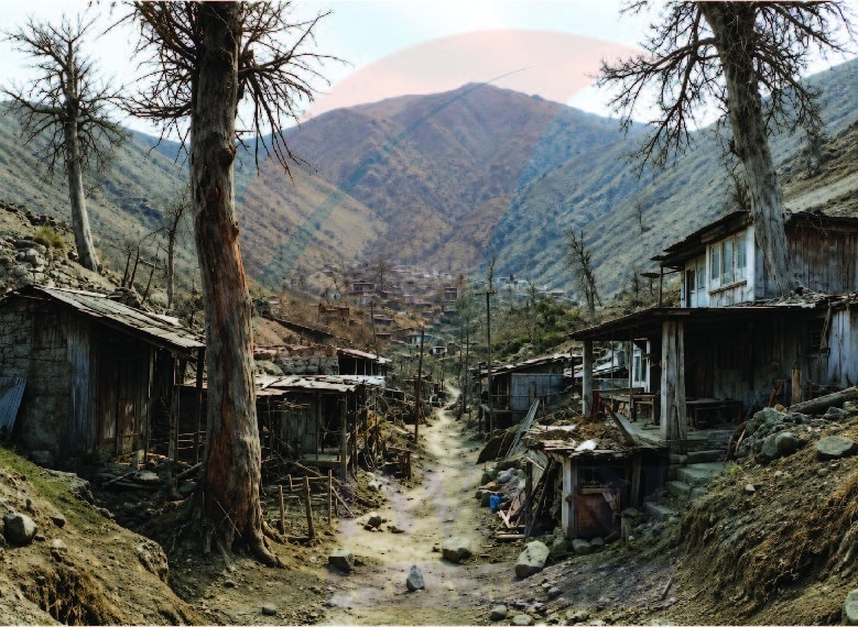
Answer:
- A volcanic eruption caused this situation. The eruption threw out large amounts of ash, dust and debris, which settled over the surrounding area, covering buildings, trees and roads.
- The grey powder is volcanic ash – fine particles of pulverized rock, minerals and volcanic glass thrown into the air during an eruption. It is very fine and can travel great distances from the volcano.
- It tells us that the Earth’s interior is extremely hot and dynamic. Molten magma from deep inside the Earth can force its way to the surface through volcanic vents, releasing enormous amounts of energy, gases and ash.
This shows that internal forces of the Earth are very powerful and can drastically change the surface landscape and affect human settlements.
Page 21 – Let’s Explore
Observe the photographs (Fig. 2.9) and also note the type of erosion. How are farmers affected by erosion due to water and wind?
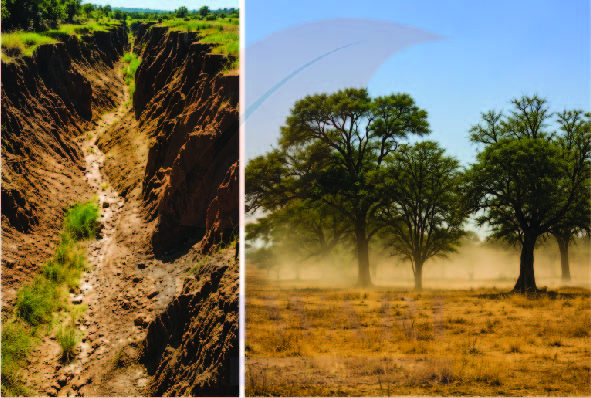
Answer:
Farmers are severely affected by erosion in the following ways:
By Water Erosion:
- Rainwater and river floods wash away the fertile topsoil from agricultural fields.
- This reduces the nutrient content of the soil, leading to lower crop yields.
- In hilly areas, water cuts deep gullies into farmland, making it unfit for cultivation.
- Flooding can destroy standing crops entirely.
By Wind Erosion:
- In dry and semi-arid regions, strong winds blow away the loose topsoil.
- This leads to desertification, where fertile land turns into barren, sandy land.
- Sand dunes can encroach upon agricultural land, burying crops.
- Wind also damages crops physically by uprooting plants or drying out soil moisture rapidly.
Page 25 – Let’s Explore
Have you heard about the Sundarbans delta? Try and explore its uniqueness and find out why it is popular with tourists.
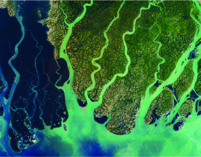
Answer:
The Sundarbans delta is the world’s largest river delta and mangrove forest, formed by the Ganga and Brahmaputra rivers at their mouths in the Bay of Bengal, spread across India (West Bengal) and Bangladesh.
Its uniqueness:
- It is home to the Royal Bengal Tiger and is a UNESCO World Heritage Site.
- It has a unique ecosystem of mangrove forests that can survive in both fresh and saltwater.
- The delta is constantly changing as new islands form and old ones submerge.
- It acts as a natural barrier against cyclones and storms for coastal communities.
- It supports rich biodiversity including crocodiles, dolphins and hundreds of bird species.
It is popular with tourists because of wildlife safaris, boat rides through dense mangroves and its rare and exotic natural beauty.
Page 32 – Let’s Explore
Observe the landforms around your school or residence and try to identify which agent may have created them.
Answer:
My school and my home are near a river, so I observe:
- Flat floodplains formed by deposition of river sediments (agent: running water)
- Small gullies or channels cut into the soil after heavy rain (agent: water erosion)
Complete the exercises given at the end of each type of disaster with the help of newspapers, atlases, and books. Make a list of disaster-prone areas from India and the world and enlist mitigation measures quoting recent examples.
Answer:
1. LANDSLIDES
Prone Areas:
- India – Uttarakhand, Himachal Pradesh, Jammu & Kashmir, Northeast India (Meghalaya, Manipur, Mizoram), Kerala (Western Ghats), Darjeeling.
- World – Nepal, China, Japan, Italy, Colombia, Philippines.
Mitigation Measures:
- Plant trees on slopes to hold soil
- Build retaining walls on unstable slopes
- Construct proper drainage systems on hillsides
- Avoid construction on steep slopes
- Install early warning systems
- Ban deforestation in hilly areas
- Relocate villages from highly dangerous zones
Recent Examples:
- Wayanad Landslide, Kerala (July 2024) – Heavy monsoon rains caused massive landslides in Mundakkai village, killing over 400 people and burying entire settlements.
- Joshimath, Uttarakhand (2023) – Town began sinking due to unplanned construction, thousands were evacuated.
2. AVALANCHES
Prone Areas:
- India – Jammu & Kashmir (Gulmarg, Sonmarg, Zoji La), Himachal Pradesh (Rohtang Pass, Spiti), Uttarakhand (higher Himalayan routes), Sikkim.
- World – Switzerland, Austria, Norway, Canada, USA (Rocky Mountains), Nepal, Pakistan.
Mitigation Measures:
- Build snow barriers and avalanche sheds on mountain roads
- Avoid trekking and skiing in high-risk zones after heavy snowfall
- Install avalanche warning systems
- Controlled blasting to release small avalanches before they become dangerous
- Plant trees on mountain slopes to reduce snow sliding
- Educate tourists and locals about safe routes
Recent Examples:
- Siachen Glacier Avalanche, J&K (2024) – Soldiers were buried under snow. Army launched rescue operations immediately.
- Kedarnath Route Avalanche, Uttarakhand (2024) – Pilgrims were stranded due to avalanche blocking the route during Char Dham Yatra season.
3. GLOFs (Glacial Lake Outburst Floods)
Prone Areas:
- India – Uttarakhand, Himachal Pradesh, Sikkim, Arunachal Pradesh, Jammu & Kashmir.
- World – Nepal, Bhutan, Pakistan, China (Tibet), Peru, Iceland.
Mitigation Measures:
- Install monitoring systems on glacial lakes to track rising water levels
- Artificially drain excess water from glacial lakes in a controlled manner
- Restrict construction of hydroelectric projects in glacial river valleys
- Set up early warning systems in downstream villages
- Prepare evacuation plans for communities near glacial rivers
- Take global action against climate change to slow glacier melting
Recent Examples:
- Chamoli GLOF, Uttarakhand (February 2021) – A glacier broke off from Nanda Devi, triggering a massive flood in Rishiganga and Dhauliganga rivers. Two hydroelectric projects were destroyed and over 200 people died.
- South Lhonak Lake GLOF, Sikkim (October 2023) – A glacial lake burst due to heavy rain and earthquake activity, sending a wall of water through Teesta river valley, destroying the Teesta-3 dam, killing over 60 people and washing away roads, bridges and entire villages.
Class 9 Social Science Chapter 2 Exercises Question Answer
Page 37 – Questions and activities
1. What are the sources of energy that are required to cause movements associated with the internal forces of the Earth?
Answer:
The internal forces of the Earth are driven by two main sources of energy:
- Heat from the Earth’s Interior:
The Earth’s core and mantle contain enormous amounts of heat generated by the decay of radioactive elements like uranium, thorium and potassium. This heat creates convection currents in the mantle – hot material rises, cool material sinks – which drives the movement of tectonic plates. - Gravitational Energy:
Gravity also plays a role. Denser, heavier material sinks toward the Earth’s center, while lighter material rises. This movement also contributes to the circulation in the mantle.
These two energy sources together power all internal forces – earthquakes, volcanic eruptions, folding and faulting – that shape the Earth’s surface from within.
2. Relate various physiographic divisions you have studied in the earlier grades with various endogenic forces responsible for their origin.
Answer:
| Physiographic Division of India | Endogenic Force Responsible |
|---|---|
| The Himalayas | Formed by convergent plate boundary – collision of Indo-Australian Plate with Eurasian Plate caused folding of rocks (fold mountains) |
| The Northern Plains | Formed by deposition of sediments eroded from the Himalayas by rivers; also related to the down warping of land due to plate collision |
| The Peninsular Plateau | One of the oldest landmasses, formed by faulting and volcanic activity (Deccan Traps formed by lava flows) |
| The Coastal Plains | Formed by faulting – when the Peninsular block rifted away, the edges subsided forming coastal lowlands |
| The Islands (Andaman & Nicobar) | Formed due to volcanic and tectonic activity along the plate boundary in the Indian Ocean |
3. Why and where do earthquakes occur frequently? It is possible to predict earthquakes?
Answer:
Earthquakes occur when stress built up along plate boundaries or faults is suddenly released. As tectonic plates move, they grind, collide or pull apart, storing enormous energy. When rocks can no longer bear this stress, they break and slip, releasing seismic waves that we feel as earthquakes.
They occur frequently:
- Along plate boundaries – convergent, divergent and transform
- The Ring of Fire around the Pacific Ocean is the most earthquake-prone region
- The Alpine-Himalayan belt (from the Mediterranean through South Asia)
- In India: the Himalayan region, Northeast India, Andaman Islands and parts of Gujarat
Currently, it is not possible to predict earthquakes with precision. Scientists can identify earthquake-prone zones using historical data and can study seismic activity patterns, but predicting the exact time, location and magnitude of an earthquake in advance is still beyond the capability of modern science. Research is ongoing, but no reliable short-term prediction method exists yet.
4. “Plate movements are responsible for the distribution of earthquakes and volcanoes”. Explain.
Answer:
Tectonic plates are constantly moving though very slowly, just a few centimetres per year. This movement creates enormous stress and friction at plate boundaries. The nature of plate movement at different boundaries explains the distribution of earthquakes and volcanoes:
- At Convergent Boundaries: When two plates collide, one may be forced under the other (subduction). The subducted plate melts and creates magma, leading to volcanic eruptions. The stress also causes powerful earthquakes. Example: The volcanoes and earthquakes of Japan and the Andes.
- At Divergent Boundaries: When plates move apart, magma rises to fill the gap, creating new crust and forming volcanoes (like mid-ocean ridges). Earthquakes also occur here but are usually less powerful. Example: The Mid-Atlantic Ridge.
- At Transform Boundaries: Plates slide past each other, generating frequent earthquakes due to friction. Example: The San Andreas Fault in California.
The Ring of Fire – the belt around the Pacific Ocean where the Pacific Plate meets several other plates – is home to about 75% of the world’s volcanoes and experiences about 90% of the world’s earthquakes. This perfectly illustrates how plate boundaries control the distribution of these events.
5. Draw a label diagram of a meander and a delta.
Answer:
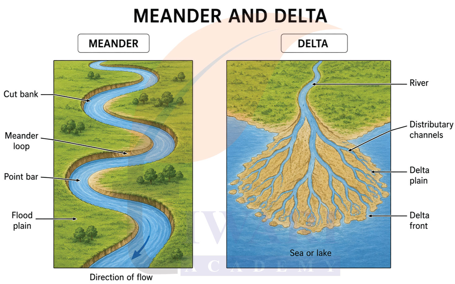
6. How are deforestation and erosion associated with each other? Explain.
Answer:
Deforestation and erosion are very closely linked:
Trees and vegetation play a vital role in holding the soil together. Their roots bind soil particles firmly and their canopy reduces the direct impact of rainwater on the ground. When forests are cut down, the soil is left exposed and unprotected.
The connection works like this:
- Without tree roots, the soil becomes loose and easily moved.
- Rainwater hits the bare ground directly with force, dislodging soil particles – this is called splash erosion.
- Without trees to absorb water, rainwater runs off quickly across the surface, carrying soil with it – this is called sheet erosion and rill erosion.
- In hilly areas, deforestation causes landslides as there are no roots to anchor the slopes.
- In dry areas, removal of vegetation allows wind to blow away the topsoil.
Thus, deforestation directly accelerates and intensifies all types of erosion – water, wind and even glacial. It is a major human-caused factor that speeds up the natural process of soil loss, leading to degraded land, reduced agricultural productivity and even desertification.
7. Develop a plan to protect the land in your local area from erosion.
Answer:
Land Protection Plan against Erosion:
- Step 1 – Afforestation: Plant trees and shrubs on bare land, slopes and riverbanks. Tree roots bind soil and prevent it from being washed or blown away.
- Step 2 – Terracing: On hilly slopes, construct step-like terraces (as done traditionally in Northeast India and Uttarakhand). This slows down water flow and prevents it from carrying soil downhill.
- Step 3 – Contour Building: Build earthen embankments along the contour lines of slopes. These slow down runoff and allow water to be absorbed into the soil.
- Step 4 – Check Dams: Construct small check dams across streams and gullies to reduce water speed, trap sediment and allow groundwater recharge.
- Step 5 – Proper Drainage: Ensure proper drainage channels in the area so that excess rainwater is directed safely without flowing across agricultural fields or eroding roads.
- Step 6 – Avoid Overgrazing: Regulate grazing by animals in grasslands and pastures to prevent destruction of grass cover, which protects the soil.
- Step 7 – Awareness: Educate local farmers and residents about sustainable land use, the importance of vegetation cover and the harmful effects of burning stubble or cutting trees.
8. Which disaster do you think you might experience in your region? Discuss a mitigation plan in your classroom.
Answer:
Delhi is located in Seismic Zone IV, which means the most likely disaster that people in Delhi can experience is an Earthquake. Delhi sits near the boundary of the Indo-Australian and Eurasian plates. The Himalayan region is constantly under tectonic stress and this stress affects Delhi as well. Past earthquakes in nearby regions like Uttarakhand and Nepal have also been strongly felt in Delhi.
Mitigation Plan for Earthquakes in Delhi
Before the Earthquake:
- Construct buildings following earthquake-resistant design as per BIS (Bureau of Indian Standards) codes
- Identify safe spots in every room such as under strong tables or near interior walls
- Keep an emergency kit ready with water, food, torch, medicines and a first aid box
- Conduct regular earthquake drills in schools, offices and residential societies
- Fasten heavy furniture and almirahs to walls so they do not fall during shaking
- Identify open grounds and parks near your home for evacuation.
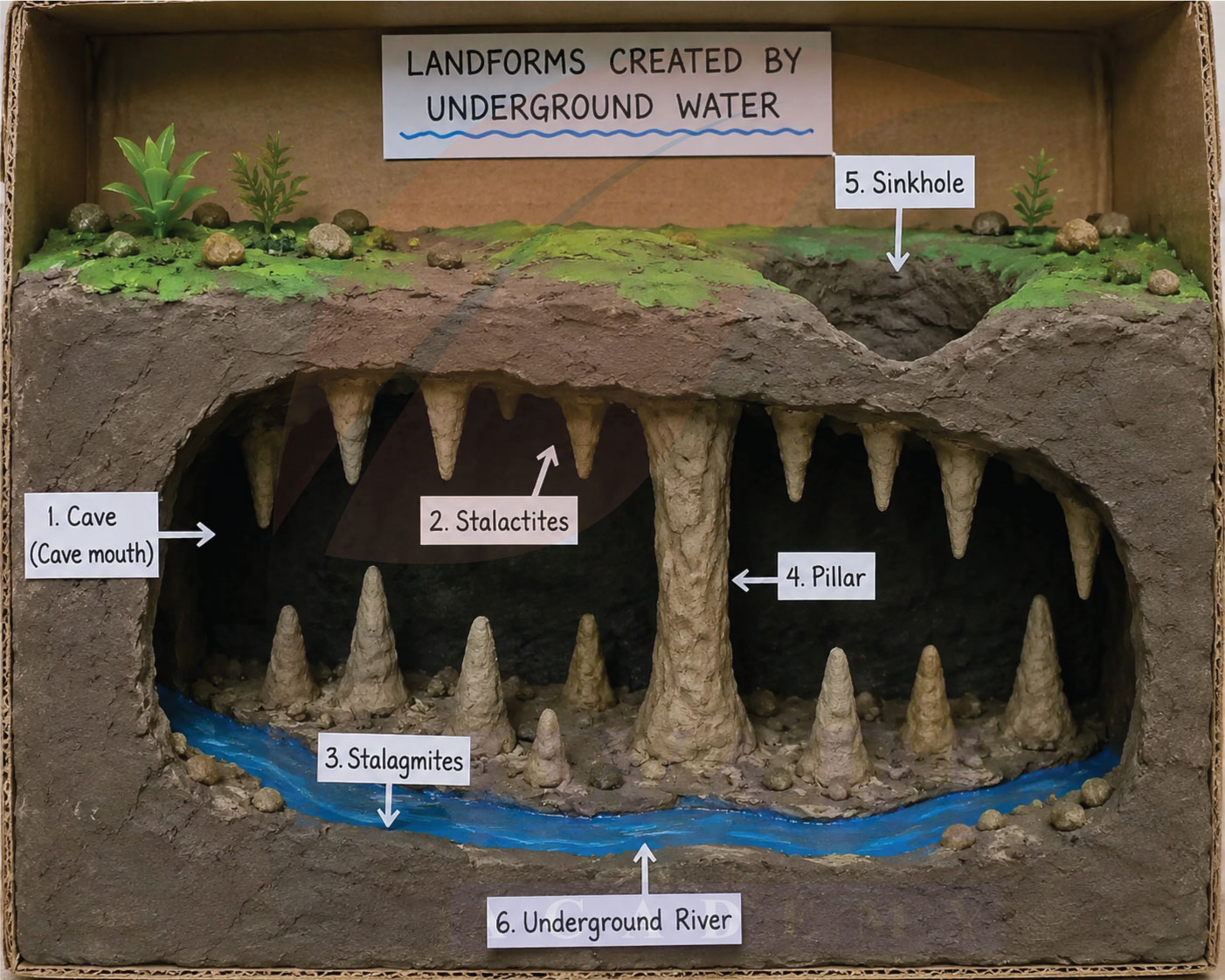
9. Prepare a model of landforms created by underground water.
Answer:
This is a practical activity. A description is given to help make the model.
How to make the model:
Materials needed: Clay or playdough, a cardboard box, blue paint, brown/grey paint, small stones, toothpicks.
What to show:
- Cave: Make a hollow space inside a clay hill. Paint the interior dark. Show the entrance (cave mouth).
- Stalactites: Hang thin cone-shaped clay pieces from the “roof” of the cave pointing downward. These form as mineral-rich water drips from the ceiling and deposits minerals over time.
- Stalagmites: Place pointed cone-shaped clay pieces rising from the “floor” of the cave, directly below the stalactites. These form from dripping water hitting the ground.
- Pillar: Where a stalactite and stalagmite meet and join, show a solid column – this is called a pillar.
- Sinkhole: On the top surface of your model, create a funnel-shaped depression to show where the ground has collapsed into an underground cavity below.
- Underground River: Show a thin blue channel running through the base of the cave system.
10. What precautionary measures will you take if you are staying in an earthquake-prone region?
Answer:
If a region is prone to earthquakes, proper precautionary measures should be taken to reduce the loss of life and property. Earthquake-resistant buildings should be constructed and heavy furniture and electrical appliances should be securely fixed to walls. People should keep an emergency kit containing drinking water, food, a first-aid box, a torch, batteries and important documents. They should also be aware of safety rules such as “Drop, Cover and Hold On” and participate in regular mock drills. During an earthquake, people should stay calm, avoid lifts and windows and move to an open area only after the shaking stops. Following these precautions can greatly reduce the impact of earthquakes and help save lives.
11. Prepare a map showing landform-associated disasters that happened in the current calendar year.
Answer:
In the year 2026, several serious landform-associated disasters have occurred across the world. The most devastating was the double earthquake that struck Venezuela on June 24, 2026. Two powerful earthquakes of magnitude 7.2 and 7.5 struck within just 39 seconds of each other near San Felipe, Yaracuy. At least 920 people were killed, more than 4,500 were injured and over 50,000 were reported missing. Venezuela sits on the South American plate, adjacent to the Caribbean plate and the earthquake occurred along the San Sebastián fault system at this plate boundary. This is a perfect real-life example of how transform and convergent plate boundaries cause devastating earthquakes. In April 2026, a M7.7 earthquake struck off the coast of Iwate, Japan, triggering a tsunami warning for northern Japan. In May 2026, the Mayon Volcano in the Philippines erupted, sending a thick column of ash into the surrounding areas. In India, the Southwest Monsoon 2026 arrived late in Kerala on June 4, and has been advancing northward, bringing heavy rainfall over West Bengal, Sikkim, Bihar, Maharashtra and other states, with risks of flash floods and landslides in Himalayan regions.
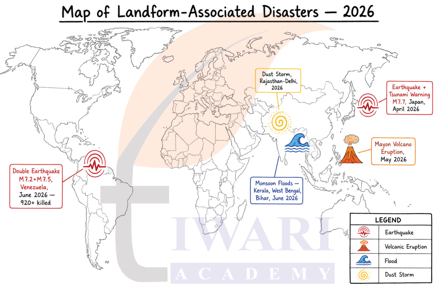
These events clearly prove that most disasters occur along plate boundaries, in mountainous regions and in flood-prone plains – showing the deep connection between landforms and natural disasters.
These disasters clearly show that most occur along plate boundaries, in mountainous regions, desert areas and flood plains – proving the strong connection between landforms and natural disasters.
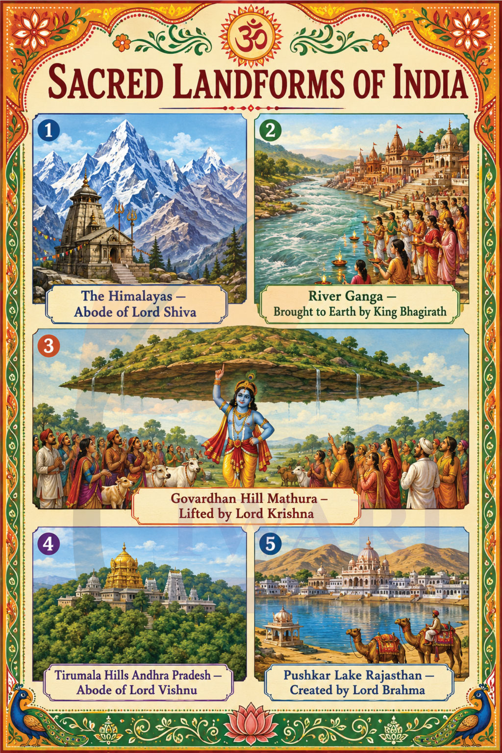
12. Create a poster showing landforms that are considered to be sacred or important in your region and add the folk stories associated with them.
Answer:
India is a land where nature and culture are deeply connected. Many landforms are considered sacred and have beautiful folk stories associated with them.
- The Himalayas – Abode of the Gods
The Himalayas are considered the home of the gods in Hindu tradition. Mount Kailash is believed to be the eternal home of Lord Shiva. According to folk belief, the river Ganga flows from his matted hair down to Earth. The Char Dham pilgrimage – Kedarnath, Badrinath, Gangotri and Yamunotri – all located in the Himalayas, are among the holiest shrines in Hinduism. - River Ganga – The Sacred River
The Ganga is worshipped as Goddess Ganga Maa. According to the story of King Bhagirath, he performed years of penance to bring the Ganga from heaven to Earth to free the souls of his ancestors. Lord Shiva caught Ganga in his matted hair to reduce her force before releasing her gently. Hindus believe bathing in the Ganga washes away all sins. - Govardhan Hill, Mathura – The Hill Krishna Lifted
Govardhan Hill in Uttar Pradesh is a very sacred landform. According to the Bhagavata Purana, when Indra sent terrible storms to punish the villagers of Vrindavan, young Krishna lifted the entire Govardhan Hill on his little finger like an umbrella and sheltered all people and animals beneath it for seven days. Devotees still perform Govardhan Parikrama – walking around the hill barefoot as an act of devotion. - Tirumala Hills, Andhra Pradesh – Where God Resides
The Tirumala Hills are home to the famous Tirupati Balaji temple. According to folk legend, Lord Vishnu himself chose to reside on these hills to be close to his devotees. The seven hills are said to represent the seven hoods of the divine serpent Shesha Naga protecting the Lord. Millions of pilgrims climb these hills every year on foot as a mark of devotion. - Pushkar Lake, Rajasthan – Created by Brahma
Pushkar Lake is the only lake in India associated with Lord Brahma. According to legend, Brahma dropped a lotus flower which fell at this spot creating the lake. A dip in its waters during Kartik Purnima is believed to free a person from all sins. The annual Pushkar Camel Fair held on its banks is one of the most famous cultural events in India.
13. Document a case of disaster that hit your region in the past, highlighting its effects on various human activities.
Answer:
Case Study: Chamoli Glacier Disaster, Uttarakhand – February 7, 2021
What happened:
On the morning of 7 February 2021, a massive chunk of a glacier broke off from the Nanda Devi mountain range in Chamoli district, Uttarakhand. The falling ice and rock triggered a massive flood in the Rishiganga and Dhauliganga rivers.
Effects on Human Activities:
- Loss of Life: Over 200 people were killed or went missing, mostly workers at hydroelectric projects.
- Destruction of Infrastructure: Two hydroelectric power projects – the Rishiganga Power Project and the NTPC Tapovan project – were almost completely destroyed, causing losses worth hundreds of crores of rupees.
- Transport Disruption: Roads, bridges and connectivity to several villages was completely cut off. People were stranded for days.
- Agriculture: Farmland along the riverbanks was buried under debris, rocks and mud, causing long-term losses to farmers.
- Livelihoods: Workers, local traders and people dependent on the hydroelectric projects lost their jobs and income.
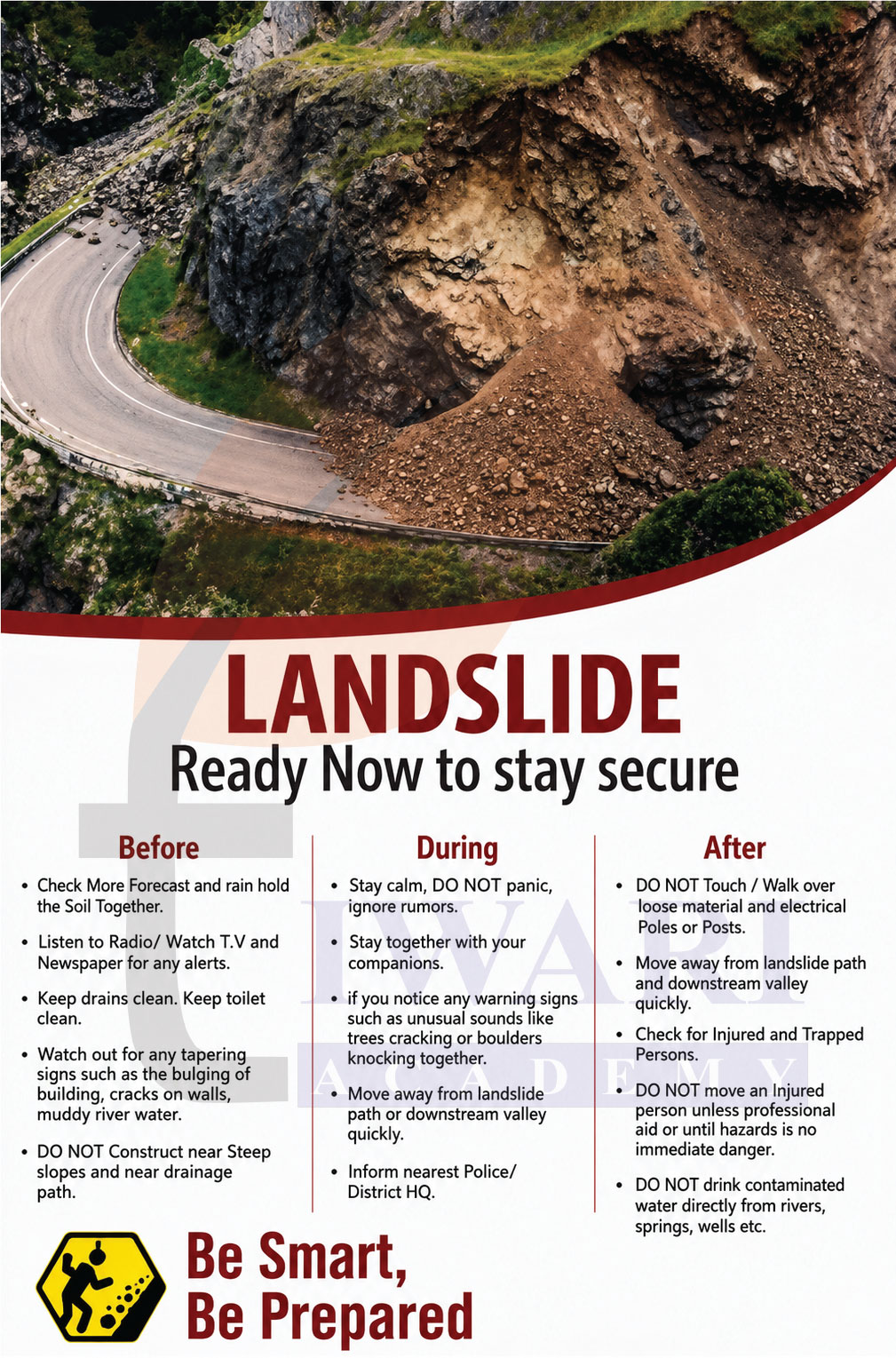
14. Translate the give poster on landslide into your native language and display it in your home.
Answer:
भूमि खिंचाव – भूकंप से सावधान
पहले:
- मिट्टी को पकड़े रखने वाले अधिक से अधिक पेड़ लगाएँ।
- रेडियो, टीवी और अख़बार पर दी जाने वाली सभी सूचनाओं को ध्यान से सुनें।
- नालियों को साफ़ रखें तथा चट्टानों की दरारों को बंद करें।
- इमारतों की नींव में दरारें तथा गंदे नदी के पानी जैसे संकेतों पर ध्यान दें।
- ढलानों और नालों के पास निर्माण न करें।
दौरान:
- शांत रहें और अफ़वाहों पर ध्यान न दें।
- अपने साथियों के साथ रहें।
- भूमि खिंचाव वाले क्षेत्र/रास्ते से तुरंत दूर हो जाएँ।
- निकट के तहसीलदार को इसकी सूचना दें।
बाद में:
- बिजली के तारों और गिरी हुई सामग्री को न छुएँ।
- भूमि खिंचाव वाले रास्तों तथा बाढ़ की घाटी से दूर रहें।
- घायल व्यक्तियों की सहायता करें।
- नदियों, झरनों और कुओं का पानी न पिएँ।
15. Divide the class into three groups. Each groups will work on one project (water, wind, and glacier). The project should highlight the causes, impact on human life and the environment, and mitigation measures.
Answer:
Group 1 – Water (Rivers, Rain, Floods)
Causes:
- Heavy and prolonged rainfall
- Deforestation reducing water absorption
- Silting of river beds reducing their capacity
- Melting of glaciers (GLOFs)
- Construction of dams and their sudden release of water
Impact on Human Life and Environment:
- Loss of lives and property
- Destruction of crops and fertile topsoil (erosion)
- Displacement of people from flooded areas
- Contamination of drinking water sources leading to diseases
- Damage to roads, bridges and infrastructure
- Positive impact: Floods deposit fertile alluvial soil which helps agriculture in the long run; rivers support irrigation
Mitigation Measures:
- Afforestation to increase water absorption
- Construction of dams and reservoirs to control water flow
- Proper embankments along rivers
- Early warning flood alert systems
- Avoiding construction in flood plains
- Practicing sustainable farming to reduce runoff
Group 2 – Wind (Dust Storms, Desert Erosion)
Causes:
- Strong winds in arid and semi-arid regions
- Prolonged drought drying out the soil
- Deforestation and overgrazing leaving soil exposed
- Climate change increasing frequency of extreme weather
Impact on Human Life and Environment:
- Reduced visibility causing accidents
- Damage to crops through physical uprooting and soil loss
- Desertification – fertile land turning into desert
- Health hazards – dust causes respiratory problems
- Damage to buildings and property
- Positive: Wind deposits fertile loess soil in some areas; wind energy can be harnessed
Mitigation Measures:
- Planting shelterbelts (rows of trees) to break wind speed
- Revegetation of barren lands
- Sustainable farming practices
- Windbreaks around farms
- Using dust masks and staying indoors during dust storms
- Reducing carbon emissions to combat climate change
Group 3 – Glaciers (Glacial Floods, Avalanches)
Causes:
- Global warming causing rapid glacial melting
- Heavy snowfall destabilizing snowpacks (avalanches)
- Earthquakes triggering glacial movement
- Human activities (trekking, construction) in mountain zones disturbing snow balance
Impact on Human Life and Environment:
- GLOFs destroying downstream villages, roads and hydroelectric plants
- Avalanches burying people, animals and settlements
- Long-term melting of glaciers threatening freshwater supply for millions of people who depend on glacier-fed rivers
- Disruption of tourism and mountain livelihoods
- Positive: Glacial meltwater feeds major rivers like the Ganga, Indus and Brahmaputra, supporting agriculture
Mitigation Measures:
- Installing early warning systems for glacial lake monitoring
- Restricting large construction projects in ecologically sensitive Himalayan areas
- Planting trees to reduce warming at local levels
- Community training for avalanche safety – building snow barriers and using controlled explosions to trigger small avalanches safely
- Global action on climate change to slow glacier melting
- Developing alternative water storage to compensate for future glacial loss
Extra Question Answers for Exam Preparation
Class 9 Social Science Chapter 2 Very Short Answer Type Questions with Explanation.
Very Short Answer Type Questions
- Who proposed the theory of plate tectonics?
Answer:
The theory of plate tectonics was proposed by W.J. Morgan. - What is a tectonic plate?
Answer:
Tectonic plates are massive slabs of solid rock that form the outermost layer of the Earth and move slowly, usually a few centimetres per year. - Name the three main layers of the Earth.
Answer:
The three main layers of the Earth are the crust, mantle, and core. - What is the asthenosphere?
Answer:
The asthenosphere is a hot, semi-molten layer beneath the lithosphere that allows tectonic plates to move. - What is the Ring of Fire?
Answer:
The Ring of Fire is the zone around the Pacific Ocean where most earthquakes and volcanoes occur, lying along tectonic plate boundaries. - Name the three types of tectonic plates.
Answer:
The three types are continental plates (carry continents), oceanic plates (carry ocean floors) and mixed plates (carry both continents and oceans). - What is weathering?
Answer:
Weathering is the process through which rocks break down into smaller pieces due to temperature changes, chemical reactions or biological activity, without any movement of material. - What is erosion?
Answer:
Erosion is the process by which soil and rocks are worn away and carried from one place to another by natural agents like water, wind or ice. - What is a delta?
Answer:
A delta is a fan-shaped landform formed at the mouth of a river where it deposits sediments while entering a sea, ocean or lake. - What are moraines?
Answer:
Moraines are landforms created by deposition of rocks, soil and debris carried and left behind by glaciers when they melt. - What is Karst topography?
Answer:
Karst topography is a unique landscape created by underground water dissolving limestone or soluble rocks, forming caves, stalactites, stalagmites and sinkholes. - What causes dust storms?
Answer:
Dust storms are caused by strong winds lifting large amounts of loose, dry soil and sand, common in desert and semi-arid regions with sparse vegetation. - What is a GLOF?
Answer:
A Glacial Lake Outburst Flood (GLOF) is the sudden release of large volumes of water from a glacial lake when its natural ice or moraine dam collapses. - What is the lithosphere?
Answer:
The lithosphere is the rigid outer layer of the Earth comprising the crust and the upper part of the mantle, broken into tectonic plates. - Name any two landforms created by wind erosion.
Answer:
Yardangs (streamlined rock ridges carved by wind) and ventifacts (rocks polished by sandblasting) are two landforms created by wind erosion.
Class 9 Social Science Chapter 2 Short Answer Type Questions with Explanation.
Short Answer Type Questions
- What are the three types of plate boundaries and what happens at each?
Answer:
At convergent boundaries, plates collide forming mountains or triggering volcanic activity. At divergent boundaries, plates move apart and new crust forms. At transform boundaries, plates slide past each other, mainly causing earthquakes like along the San Andreas Fault. - How do convection currents cause plate movement?
Answer:
Heat from the Earth’s core causes molten material in the mantle to rise, while cooler material sinks. This continuous circulation creates convection currents that push and pull tectonic plates, causing them to move in different directions. - What are the three types of weathering? Give one example of each.
Answer:
Physical weathering occurs due to temperature changes or frost. Chemical weathering happens when minerals react with water or acids. Biological weathering is caused by plants or animals, for example, plant roots growing into rock cracks and splitting them apart. - How does a meander form and why is it important for humans?
Answer:
A meander is a winding bend in a river formed by lateral erosion on outer banks and deposition on inner banks. The fertile soil along meanders supports agriculture, influences settlement patterns and rivers are used for irrigation and navigation. - Explain how glaciers create U-shaped valleys and moraines.
Answer:
Glaciers widen and deepen river valleys as they move, carving U-shaped valleys. When glaciers melt, they deposit rocks, soil and debris called till, forming moraines. These can create fertile soil for agriculture and natural dams for water storage. - What is a beach and how does it benefit humans?
Answer:
A beach is a landform of sand, pebbles or rocks along a shoreline, created by wave deposition. Beaches serve as tourist destinations, fishing areas and natural barriers against coastal erosion, boosting local economies and protecting nearby settlements. - How does erosion affect human livelihoods?
Answer:
Erosion removes fertile topsoil reducing crop yields for farmers. It washes away land, houses and roads near rivers and coasts. It destabilises land in construction and mining and damages beaches and rivers that tourism and fishing industries depend on. - What are the causes of landslides?
Answer:
Landslides are caused by heavy rainfall, earthquakes, volcanic eruptions, steep slopes and loose weathered rocks. Human activities like deforestation, mining, road construction and unplanned hillside construction also disturb slope stability, while poor drainage allows excess water to accumulate causing sudden slope failure. - What is the Sundarbans delta and why is it significant?
Answer:
The Sundarbans is a famous delta formed where rivers meet the sea in the Bay of Bengal. It is one of the world’s largest mangrove forests, rich in biodiversity and is popular with tourists for its unique ecological features. - Name and explain the types of dunes formed by wind.
Answer:
Barchan dunes are crescent-shaped, formed with limited sand and single wind direction. Longitudinal dunes are long ridges parallel to wind. Star dunes have multiple arms from winds of different directions. Parabolic dunes are U-shaped and often stabilised by vegetation.
Class 9 Social Science Chapter 2 Long Answer Type Questions with Explanation.
Long Answer Type Questions
Describe the interior structure of the Earth and explain how it relates to plate tectonics.
Answer:
The Earth has three main layers – the crust, mantle and core. The crust is the outermost layer we live on, varying from 5–7 km under oceans to 30–40 km under continents. Below it lies the thick, hot mantle, and at the centre is the extremely hot and dense core, divided into a liquid outer core and a solid inner core.
The crust and upper mantle together form the lithosphere, which is broken into tectonic plates. Beneath the lithosphere lies the asthenosphere, a semi-molten layer that allows these plates to move. Heat from the core creates convection currents in the mantle that drive this plate movement, giving rise to earthquakes, volcanoes and major landforms on Earth’s surface.
Explain how rivers shape the Earth’s surface at different stages of their course.
Answer:
Rivers are powerful agents of gradation that shape the land through erosion, transportation and deposition at different stages of their course.
In the upper course, rivers flow steeply and with great force, forming V-shaped valleys, waterfalls and rapids. Waterfalls form where hard rocks resist erosion while softer rocks below are worn away, creating a sudden vertical drop. These are often harnessed for hydroelectric power and attract tourists.
In the middle course, the river loses speed and begins to meander, forming winding bends. Erosion on outer banks and deposition on inner banks gradually creates oxbow lakes and floodplains. The fertile soil here supports agriculture and human settlements.
In the lower course, the river slows further and deposits large amounts of sediment, forming deltas, levees and alluvial fans at the river’s mouth. Deltas are highly fertile and support dense populations, rice and jute farming and fishing communities.
Discuss the role of plate tectonics in causing earthquakes and volcanic eruptions, with reference to plate boundaries.
Answer:
Plate tectonics is the primary cause of earthquakes and volcanic eruptions on Earth. As tectonic plates move, they interact at their boundaries in three ways, each producing different geological effects.
At convergent boundaries, two plates move toward each other. When continental plates collide, they push up fold mountains like the Himalayas. When an oceanic plate meets a continental plate, the denser oceanic plate sinks beneath in a process called subduction, generating intense heat that causes volcanic eruptions and powerful earthquakes.
At divergent boundaries, plates move apart and magma rises to fill the gap, forming new crust and features like the Mid-Atlantic Ridge. This process also causes earthquakes.
At transform boundaries, plates slide horizontally past each other without creating or destroying crust, but the friction between them causes frequent and destructive earthquakes, as seen along the San Andreas Fault in the United States.
Most earthquakes and volcanoes are concentrated along these plate boundaries, particularly around the Pacific Ocean in the region known as the Ring of Fire. India too faces earthquake risk, as evidenced by the devastating Gujarat earthquake of 2001.
Describe the various landforms created by coastal erosion and explain their significance for humans.
Answer:
Coastal erosion occurs when waves, tides and currents continuously wear away land along the shore, creating a variety of distinctive landforms over time.
Cliffs are steep rock faces formed when waves undercut the base of the coast. As cliffs retreat, they leave behind wave-cut platforms – flat rocky surfaces exposed at low tide. Where waves erode weaker parts of a rock, caves are formed. When caves develop on opposite sides of a headland and eventually meet, they form arches. Over time, when arches collapse, isolated pillars of rock called stacks are left standing.
Beaches are formed by deposition of sediments by waves and are among the most human-significant coastal landforms. They serve as popular tourist destinations, support fishing communities and act as natural barriers protecting settlements from strong waves and storm surges.
These coastal landforms are important not only geologically but also economically, as they attract tourism and recreation. However, cliffs and eroding coastlines may threaten settlements, requiring coastal protection measures to safeguard human life and property.
What are the major landform-associated disasters discussed in the chapter? Explain their causes and impact on human life.
Answer:
The chapter discusses four major landform-associated disasters – landslides, avalanches, GLOFs and dust storms – each linked to specific landforms and posing serious threats to human life.
Landslides occur when slopes become unstable due to heavy rainfall, earthquakes, deforestation, mining or unplanned construction. Water seeping into soil increases weight and reduces friction, causing sudden slope failure. These destroy roads, buildings and farmland, and cause loss of life in hilly regions.
Avalanches are triggered on steep, snow-covered mountain slopes when heavy snowfall, rising temperatures, strong winds or human activities like skiing and trekking disturb the snow balance. They can bury entire settlements and block transport routes in mountainous areas.
GLOFs occur when glacial lake dams made of ice or moraines suddenly burst due to rising temperatures, heavy rainfall, earthquakes or landslides. The flash floods that follow cause massive destruction downstream, as seen in the Chamoli disaster in Uttarakhand in 2021.
Dust storms arise in desert and semi-arid regions when strong winds lift loose, dry soil. Deforestation, overgrazing, poor farming and climate change worsen their frequency. They reduce visibility, damage crops, cause respiratory illness and disrupt daily life across large areas.
Frequently Asked Questions
What is Class 9 Social Science Chapter 2 about?
Class 9 Social Science Chapter 2, Shaping of the Earth’s Surface, is part of the Geography section of the textbook Understanding Society: India and Beyond. It covers plate tectonics, weathering and erosion, landforms created by water, wind, glaciers and underground water and natural disasters associated with different landforms.
Which book does Class 9 Social Science Chapter 2 belong to?
This chapter belongs to Understanding Society: India and Beyond – Grade 9, Part 1, which is the new NCERT Social Science textbook introduced for Class 9.
What are the main topics covered in Chapter 2 of Class 9 Social Science?
The chapter covers plate tectonics and Earth’s interior, types of plate boundaries, weathering and erosion, agents of gradation (running water, glaciers, wind, waves, underground water), various landforms like deltas, meanders, dunes, caves and landform-related disasters such as landslides, avalanches, GLOFs and dust storms.
Is Social Science Chapter 2 important for Class 9 exams?
Yes, this chapter is very important for Class 9 Geography exams. Topics like plate tectonics, types of erosion, landforms formed by rivers and glaciers and disaster-related questions are commonly asked in school examinations and competitive assessments.
Who proposed the theory of plate tectonics mentioned in Class 9 Social Science Chapter 2?
The theory of plate tectonics was proposed by W.J. Morgan. It explains how the Earth’s crust is divided into tectonic plates that move slowly over the semi-molten asthenosphere, giving rise to landforms and natural phenomena like earthquakes and volcanoes.