



by Tiwari Academy Team
NCERT Class 7 Social Science Chapter 1 Part 1 Geographical Diversity of India Solutions in English and Hindi Medium – Exercises and Extra Question Answers. Chapter 1 of Class 7 Social Science, Geographical Diversity of India, is the opening chapter of the new NCERT book Exploring Society: India and Beyond for the 2026-27 session. The chapter takes students on a journey across India’s varied landscapes – from the towering Himalayas in the north to the cold desert of Ladakh, the fertile Gangetic Plains, the golden dunes of the Thar Desert, the ancient Aravalli Hills, the Peninsular Plateau, India’s long coastline, the islands of Lakshadweep and Andaman & Nicobar and the rain-soaked hills of the Northeast. Along the way, students learn how mountains, rivers, deserts and coasts have shaped India’s climate, culture, wildlife and the everyday lives of its people. With engaging boxes like “Let’s Explore”, “Let’s Remember” and “Don’t Miss Out”, this chapter builds a strong foundation for understanding India’s physical geography in a simple, story-like manner suited for Grade 7 learners.
Quick Links:
- Exercises Question Answers
- Very Short Answer Type Questions
- Short Answer Type Questions
- Long Answer Type Questions
- Class 7 Social Science Chapter 1 in Hindi Medium
- Download Class 7 Social Science App to study Class 7 Social Offline.
NCERT Class 7 Social Science Chapter 1 Solutions
Class 7 Social Science Part 1 Chapter 1 Question Answer
Page 1 – The Big Questions
1. What are some geographical features in India?
Answer:
India has five major regions: the great mountain zone (the Himalayas), the plains of the Ganga and the Indus, the desert region (Thar Desert), the southern peninsula (the Peninsular Plateau with the Western and Eastern Ghats) and the islands (Lakshadweep, Andaman and Nicobar). India is bordered by the Himalayas in the north, the Thar Desert and Arabian Sea in the west, the Indian Ocean in the south and the Bay of Bengal in the east.
2. How does India’s geographical diversity affect our lives?
Answer:
Geographical diversity affects the type of soil, climate, plants, animals, food habits, clothing, housing styles, occupations and culture of people living in different regions. For example, people in the Thar Desert have adapted to water scarcity, people in the Himalayas build houses suited to cold weather (like kath-kuni houses) and the fertile Gangetic plains support dense population and agriculture. It also affects economic activities like farming, mining, fishing and tourism.
Page 2 – Let’s Explore
Look at the map of India at the end of this book. What are you able to observe? Recall your lesson on different types of landforms -mountains, plains and plateaus. Which landforms can you identify on the map? What do the different colours on the map mean?
(Hint: The legend on the map shows the heights of each area.)
Answer:
On the physical map, we can identify mountains (like the Himalayas and Western/Eastern Ghats), plains (the Gangetic and Indus plains), plateaus (the Deccan Plateau) and deserts (Thar Desert). The different colours on the map represent different altitudes/heights of the land – usually green for low-lying plains, yellow/brown for higher plateaus and darker brown/white for the highest mountain areas.
Page 3 – Let’s Explore
Do you recall your lesson on latitudes and longitudes? Look at the map. Can you read, approximately, the latitude and longitude where India lies?
Answer:
India lies approximately between 8°N to 37°N latitude and 68°E to 97°E longitude.
Identify the above features on India’s physical map.
Answer:

Page 4 – Let’s Remember
The Himalayas seem to touch the sky. In fact, many of its peaks are over 8000 metres in height and are together called the ‘Eight Thousanders’. This mountain range stretches across six countries in Asia: India, Nepal, Bhutan, China, Pakistan and Afganistan. Can you name the highest mountain in the world?
Answer:
Mount Everest, located in the Himalayas (on the border of Nepal and China/Tibet), is the highest mountain in the world, at about 8,849 metres.
Page 6 – Let’s Explore
Can you locate tha names of the states in the different parts of the Himalayas? Take the help of both the physical and political maps for this exercise.
Answer:
States located in different parts of the Himalayas (from west to east):
Jammu & Kashmir
Ladakh
Himachal Pradesh
Uttarakhand
Sikkim
West Bengal (Darjeeling hills)
Arunachal Pradesh
Assam (foothills)
Page 11 – Let’s Explore
Notice the concentration of lighting in the plains. What could be the reason for this concentration?
Answer:
The Gangetic Plains are densely populated and highly urbanised because the land is flat and fertile, water is easily available from rivers and it has been a centre of civilisation, trade and agriculture for thousands of years. More people and more cities mean more electric lighting, visible clearly from space.
Page 12 – Let’s Explore
What is the shape of a sand dune? While mountains are made of rock and their shape is fixed, why do you think sand dunes also have a similar shape, even though they are made of sand?
Answer:
Sand dunes are shaped by wind, which constantly blows and shifts loose sand grains in a similar pattern over time. Since wind mostly blows in similar directions in a desert region, it naturally piles up sand into similar curved, wave-like shapes – unlike solid rock mountains, which are shaped once by geological forces and don’t change shape easily afterward.
Page 14 – Let’s Explore
Let’s go back to the map. Trace your path slowly from the Thar Desert towards the east. Do you see the Aravali Hills?
Answer:

Page 15 – Let’s Explore
Look at the political map in the textbook and identify the states that the range spans. Did you see Delhi, Rajasthan, Haryana and Gujarat?
Answer:
Yes, the Aravalli Range spans across these states:
- Rajasthan
- Gujarat
- Haryana
- Delhi
Page 16 – Let’s Explore
Look at the physical map of India given at the end of the book. Notice the direction of the flow of the rivers.
Answer:

Looking at the physical map, the rivers of the Peninsular Plateau flow in two main directions:
- West-flowing rivers: Narmada and Tapti – flow towards the west and drain into the Arabian Sea.
- East-flowing rivers: Godavari, Krishna, Kaveri and Mahanadi – flow towards the east and drain into the Bay of Bengal.
Page 17 – Let’s Explore
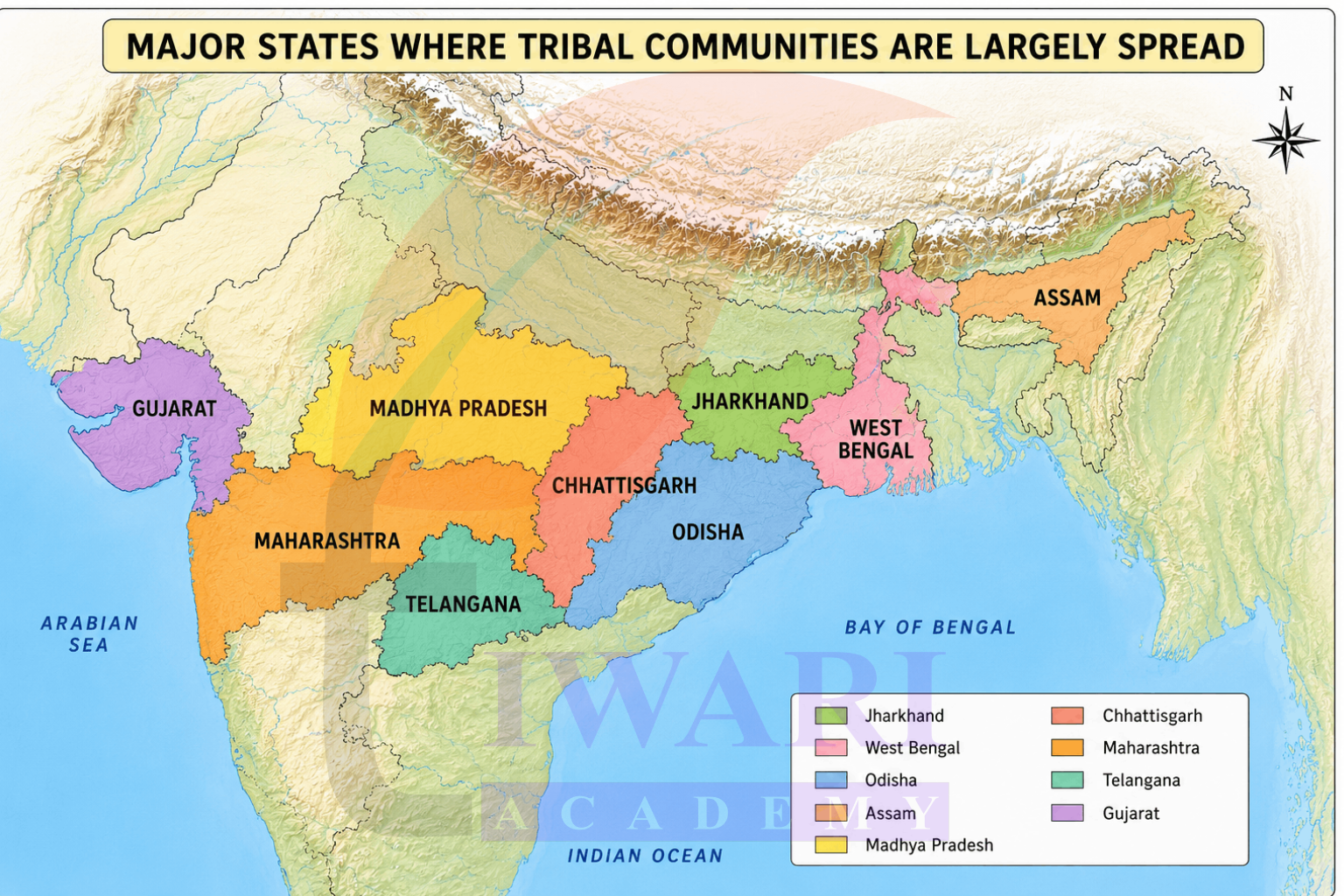
Tribal communities are largely spread over the state of Jharkhand, West Bengal, Odisha, Assam, Madhya Pradesh, Chhattisgarh, Maharashtra, Telangana and Gujarat. Examine the physical and political maps at the end of this book to locate the states and connect them to their location on the physical map.
Answer:
Page 19 – Let’s Explore
Look at the physical map of India in your school atlas or wall map and find the names of five rivers that flow into the Bay of Bengal. Find out India’s coastal states and discuss the difference between the western and eastern coastal plains
Answer:
Rivers flowing into the Bay of Bengal: Ganga, Brahmaputra, Mahanadi, Godavari, Krishna, Kaveri.
Difference between the coasts: The west coast is narrow, with the Western Ghats running close to the sea, fewer large river deltas and features like creeks, coves and estuaries (e.g., Narmada and Tapti estuaries). The east coast is wider and flatter, with big river deltas (Mahanadi, Godavari, Krishna, Kaveri) since the land slopes gently toward the Bay of Bengal, making it more suitable for large-scale farming.
Do you know what it is called when these rivers split into multiple streams near the coast? Discuss with your teacher in class to find out!
Answer:
This is called a delta a triangular or fan-shaped landform created when a river deposits sediment as it splits into multiple smaller streams before meeting the sea.
Questions and activities
1. What, in your opinion, are two important geographical features of India? Why do you think they are important?
Answer:
Two important geographical features are:
- The Himalayas: These mountains form a massive natural barrier in the north. They are important because they are the source of major rivers like the Ganga, Indus and Brahmaputra which provide essential water for millions, influence India’s climate and hold cultural significance.
- The Peninsular Plateau and Coastlines: This large triangular region surrounded by coasts is rich in minerals and forests. The long coastlines are vital for trade, fishing and support major cities. Its rivers are important for farming and hydroelectric power.
2. What do you think India might have looked like if the Himalayas did not exist? Write a short note or sketch a drawing to express your imagination.
Answer:
If the Himalayas didn’t exist:
- Climate: India’s climate would likely be drastically different, possibly much colder in the north without the mountains blocking cold winds from Central Asia and monsoon patterns might be altered.
- Rivers: The great rivers like the Ganga, Indus and Brahmaputra, which are fed by Himalayan snowmelt, might not exist or would be much smaller, leading to less fertile northern plains.
- Landscape: The vast, fertile Gangetic Plains might not have formed in the same way, as they are built by sediments from Himalayan rivers. The northern border of India would be dramatically different.
- History: Without the Himalayan barrier, historical migrations and invasions from the north might have been more frequent, potentially changing India’s cultural and political history.
3. India has been called a ‘mini-continent’. Based on what you’ve read, why do you think this is so?
Answer:
India is called a ‘mini-continent’ because of its vast size (seventh-largest country) and incredible geographical diversity. It encompasses a wide range of distinct landforms and climates within its borders, including: high mountains (Himalayas), vast plains (Gangetic Plains), deserts (Thar), plateaus (Peninsular Plateau), long coastlines and islands. This sheer variety creates distinct regions similar to the diversity found across an entire continent.
4. Follow one of India’s big rivers from where it starts to where it meets the ocean. What are the different ways in which people might utilise this river along its journey? Discuss in groups in your class.
Answer:
Let’s follow the Ganga:
- Origin: Starts from the Gangotri Glacier (Gaumukh) in the Himalayas. Uses here include pilgrimage and sourcing freshwater.
- Journey through Plains: People use its water extensively for irrigation (supporting agriculture), drinking water and industrial use. The river is used for transportation and trade. Large populations and cities thrive along its banks.
- Meeting the Ocean: Near the Bay of Bengal, the Ganga forms a large delta. The fertile delta land is used for agriculture (like paddy). The river network supports fishing and unique ecosystems like the Sundarbans.
5. Why is the southern part of India referred to as a peninsular plateau?
Answer:
It’s called a peninsular plateau because:
- Peninsula: The southern part of India is a large landmass surrounded by water on three sides – the Arabian Sea (west), the Bay of Bengal (east) and the Indian Ocean (south).
- Plateau: This region consists mainly of a large, relatively flat-topped highland area that rises significantly above the surrounding coastal plains (including the Deccan Plateau).
6. Which UNESCO Heritage Site mentioned in this chapter did you find more interesting? Write a short paragraph to describe what about it is interesting.
Answer:
I found the Sundarbans the most interesting UNESCO World Heritage Site mentioned in this chapter. It is located in the delta formed by the Ganga, Brahmaputra and their tributaries and about half of it lies in India while the rest is in Bangladesh. What makes it fascinating is that it is a unique mix of river, sea and land, covered with mangrove forests that can survive in salty water. It is also home to the famous Royal Bengal Tiger, which has adapted to swimming and hunting in this watery, marshy environment – something you don’t usually imagine tigers doing! I would love to visit the Sundarbans someday to see the mangroves and spot a Royal Bengal Tiger in its natural habitat.
7. Look at the two maps of India, physical as well as political, given at the end of this book. Identify the place you are at now. Which physical feature of India would you use to describe its location?
Answer:
I am currently in Delhi. Looking at the physical map of India, I can see that Delhi lies in the Northern Plains (Gangetic Plains), close to the point where the Aravalli Hills end on one side. The river Yamuna flows through Delhi, which is a tributary of the Ganga. So, I would describe my location using the physical feature of the Northern Plains, since Delhi lies on the flat, fertile land formed by rivers flowing down from the Himalayas and is also near the northeastern edge of the Aravalli range.
8. Food preservation techniques differ from place to place across India. They are adapted to local conditions. Do a class project. Gather different methods of preserving food. Hint: Drying vegetables when they are in season for use during the off-season.
Answer:
Food preservation methods adapt to India’s diverse geography:
- Drying: Common in sunny regions for vegetables, fruits, fish.
- Pickling: Widespread method using oil, salt, vinegar, spices.
- Salting/Curing: Common in coastal areas for fish; also for vegetables/meats.
- Smoking: Used in some humid or hilly areas for fish and meat.
- Fermentation: Used for idli/dosa batter, curd, some pickles.
- Making Jams/Jellies/Murabba: Using high sugar concentration for fruits.
9. Despite having such different regions (mountains, deserts, plains, coasts), India remains one country. How do you think our geography has helped unite people?
Answer:
Geography may contribute to unity through:
- Defined Boundaries: Natural barriers like the Himalayas and oceans create a distinct geographical entity.
- Interdependence: Major rivers flowing through multiple regions create dependency on shared resources.
- Complementary Resources: Different regions possess different resources, encouraging trade and interaction.
- Cultural Exchange: Geographical features have channeled movement, pilgrimage and trade over millennia, leading to shared cultural threads.
- Shared Challenges/Opportunities: Facing common environmental factors or utilizing shared infrastructure can foster collective identity.
Class 7 Social Science Part 1 Chapter 1 Extra Questions for Exam Preparation
Class 7 Social Science Part 1 Chapter 1 Very Short Answer Type Questions.
Very Short Answer Type Questions
1. Name the mountain range that forms India’s northern boundary.
See AnswerThe Himalayas form India’s natural mountain barrier in the north.
2. What is the length of the Himalayan range?
See AnswerThe Himalayan range is about 2500 km long.
3. Name the three main ranges of the Himalayas.
See AnswerHimadri, Himachal and the Shivalik Hills.
4. Which river’s tributary originates from Gaumukh?
See AnswerThe Bhagirathi River, a tributary of the Ganga, originates from Gaumukh.
5. Which is the cold desert of India?
See AnswerLadakh is the cold desert of India, also called “moonland”.
6. Name the desert located in Rajasthan.
See AnswerThe Thar Desert, also called the Great Indian Desert.
7. What is a peninsula?
See AnswerA peninsula is land surrounded by water on three sides.
8. Name two rivers flowing across the Peninsular Plateau.
See AnswerThe Godavari and the Krishna rivers.
9. Which mountain range borders the Peninsular Plateau on the west?
See AnswerThe Western Ghats border it on the west.
10. Name India’s two major island groups.
See AnswerLakshadweep and the Andaman and Nicobar Islands.
11. Which island has India’s only active volcano?
See AnswerBarren Island has India’s only active volcano.
12. Name the delta region famous for the Royal Bengal Tiger.
See AnswerThe Sundarbans delta in West Bengal.
13. What are the Aravalli Hills known for?
See AnswerThey are among the oldest mountains in the world, rich in minerals.
14. Which hills are found in the Northeast of India?
See AnswerThe Garo, Khasi and Jaintia Hills of Meghalaya.
15. What is the approximate length of India’s coastline?
See AnswerIndia’s coastline is over 7500 km long.
Class 7 Social Science Part 1 Chapter 1 Short Answer Type Questions.
Short Answer Type Questions
1. How were the Himalayas formed?
See AnswerIndia was once part of Gondwana. It broke away and drifted north, colliding with the Eurasian plate about 50 million years ago. The land between them folded and rose upward, forming the Himalayan mountains, which are still growing slowly today.
2. Why is Ladakh called a “cold desert”?
See AnswerLadakh receives very little rainfall and has extremely low winter temperatures, often below –30°C. Despite the cold, it shares desert-like features such as dry, rocky terrain, which is why it is called a cold desert.
3. Why is the Thar Desert considered a natural barrier?
See AnswerThe Thar Desert has harsh conditions like extreme daytime heat, cold nights and scarce water, which discourage easy human and animal movement. This makes it act as a natural barrier along India’s western border.
4. What role do the Aravalli Hills play in India’s geography?
See AnswerThe Aravalli Hills prevent the Thar Desert from spreading further eastward, protecting the fertile plains beyond. They are also rich in minerals like marble, zinc and copper, supporting mining activities for centuries.
5. What is the difference between the Western Ghats and Eastern Ghats?
See AnswerThe Western Ghats are taller, continuous and run like a wall along the west coast with many waterfalls. The Eastern Ghats are lower, broken into smaller hills and lie along the eastern coast.
6. Why are the Gangetic Plains important for India’s population?
See AnswerThe Gangetic Plains are fertile due to minerals brought by rivers like the Ganga, Indus and Brahmaputra. This fertility supports large-scale farming, which is why a large proportion of India’s population lives here.
7. What are deltas, and which rivers form them in India?
See AnswerDeltas are triangular landforms created when rivers deposit sediments at their mouth before meeting the sea. In India, the Godavari, Krishna, Kaveri and Mahanadi rivers form fertile deltas along the east coast.
8. How do people in the Thar Desert adapt to water scarcity?
See AnswerPeople travel long distances to fetch water and use sand to scrub utensils instead of water. Rajasthan is also known for traditional rainwater-harvesting systems like taanka and kunds that store rainwater for drinking.
9. Why are the Andaman Islands historically significant?
See AnswerThe Andaman Islands house the Cellular Jail, where many Indian freedom fighters were imprisoned under harsh conditions during British rule. The jail has been preserved as a reminder of their sacrifices for India’s freedom.
10. What makes the Northeast hills, like Meghalaya, geographically unique?
See AnswerThe Meghalaya Plateau, including the Garo, Khasi and Jaintia Hills, receives one of the highest rainfalls in the world. This heavy rainfall supports dense forests, unique wildlife and features like living root bridges.
Class 7 Social Science Part 1 Chapter 1 Long Answer Type Questions.
Long Answer Type Questions
1. Describe the three ranges of the Himalayas and their features.
See AnswerThe Himalayas are divided into three main ranges. The Himadri, or Greater Himalayas, are the highest and most rugged, home to peaks like Mount Everest and Kanchenjunga and remain snow-covered throughout the year with very few settlements. The Himachal or Lower Himalayas, have a moderate climate and host popular hill stations like Shimla, Nainital and Darjeeling. The Shivalik Hills or Outer Himalayas, form the lowest and outermost range, with rolling hills and dense forests that act as a transition zone between the mountains and the Gangetic Plains.
2. Explain the significance of the Peninsular Plateau in India’s geography and economy.
See AnswerThe Peninsular Plateau is a triangular, very old landmass located in the middle and south of India, bordered by the Western and Eastern Ghats. It is bounded by the Arabian Sea, the Bay of Bengal and the Indian Ocean, making it a true peninsula. The plateau is rich in minerals, forests, fertile land and rivers like the Godavari, Krishna, Mahanadi, Narmada and Tapti flow across it, supporting farming, industries and hydroelectric power generation. Its dense forests are also home to many tribal communities such as the Gond, Bhil, Santhal and Baiga.
3. Describe the geographical features and importance of India’s coastline.
See AnswerIndia’s coastline stretches over 7500 km and is divided into the West Coast and the East Coast. The West Coast, from Gujarat to Kerala, is shaped by short, swift rivers from the Western Ghats that form estuaries, coves and creeks. The East Coast lies between the Eastern Ghats and the Bay of Bengal, featuring wide plains and major river deltas formed by the Mahanadi, Godavari, Krishna, and Kaveri. The coastline hosts important ports, cities and water bodies like Chilika and Pulicat Lake, making it vital for trade and economic activity.
4. What are the Indian Islands, and why are they important?
See AnswerIndia has two major island groups: Lakshadweep, an archipelago of 36 coral islands in the Arabian Sea near Kerala and the Andaman and Nicobar Islands, comprising over 500 volcanic islands in the Bay of Bengal. These islands are rich in unique wildlife, coral reefs, and beautiful beaches and some have been home to ancient tribes for thousands of years. They are strategically important for India, allowing fishing, resource exploration, environmental protection, and naval presence, while the Andamans also hold deep historical value linked to India’s freedom struggle.
5. How has India’s geographical diversity shaped the lives and culture of its people?
See AnswerIndia’s varied landforms, from snowy mountains to hot deserts and fertile plains to tropical coasts, have led people to develop different lifestyles suited to their surroundings. In the Himalayas, people rely on yaks and build sacred monasteries; in the Thar Desert, they conserve water carefully and build heat-resistant homes; in the Gangetic Plains, farming and dense settlements thrive due to fertile soil; and coastal and island communities depend on fishing and trade. This diversity has created rich cultural traditions, distinct food habits and varied economic activities across the country, while still uniting India as one nation.
Frequently Asked Questions
1. What is Class 7 Social Science Chapter 1 “Geographical Diversity of India” about?
This chapter introduces students to the major physical features of India, including the Himalayas, the Gangetic Plains, the Thar Desert, the Aravalli Hills, the Peninsular Plateau, the coastline and the islands. It explains how these landforms were created and how they influence the climate, farming, culture and lifestyle of people living in each region. The chapter is meant to give young learners a bird’s-eye view of India’s geography before going into deeper detail in later classes.
Which textbook does Class 7 Chapter 1 belong to for the 2026-27 session?
This chapter is Chapter 1 of the new NCERT book titled Exploring Society: India and Beyond, Grade 7 Part 1, published under the revised curriculum for the academic session 2026-27. It replaces the earlier Class 7 Geography textbook and is part of NCERT’s updated syllabus that combines geography, history and civics into a single integrated social science book.
Why are the Himalayas important according to Class 7 Social Science Chapter 1?
The Himalayas act as a natural wall in the north, feeding major rivers like the Ganga, Indus and Brahmaputra through melting snow. This is why they are called the “Water Tower of Asia”. They also influence India’s climate by blocking cold winds from Central Asia and hold deep cultural and religious importance, with many temples and monasteries built within them.
What are the five main geographical regions of India mentioned in Class 7 Social Science Chapter 1?
The chapter divides India into five broad regions for easier understanding: the great mountain zone (Himalayas), the plains of the Ganga and Indus, the desert region (Thar Desert), the southern peninsula (Peninsular Plateau) and the islands (Lakshadweep and Andaman & Nicobar). Each region has its own unique landforms, climate and way of life, which the chapter explores one by one.
How can parents help their child understand Class 7 Social Science Chapter 1 better?
Parents can encourage their child to trace India’s physical map while reading, pointing out mountains, rivers, deserts and coasts as mentioned in the text. Watching documentaries on the Himalayas, Thar Desert or Sundarbans and discussing real-life examples like hydroelectricity from waterfalls, can make the geography come alive and easier to remember for exams.
What exam-important terms should students focus on in Class 7 Social Science Chapter 1?
Students should clearly understand terms such as peninsula, plateau, delta, archipelago, estuary and lagoon, since these are commonly asked in short-answer questions. Knowing the difference between the Western and Eastern Ghats and the three ranges of the Himalayas (Himadri, Himachal, Shivalik), is also important for scoring well in tests.
Is Class 7 Social Science Chapter 1 useful for competitive exams or only school exams?
While this chapter is primarily designed for Class 7 school assessments, the basic geography concepts it covers – such as landforms, rivers, deserts and coastlines of India – form a foundation that is useful for future competitive exams too. Building a clear picture of India’s physical geography early on helps students in higher classes and general knowledge tests later.