



by Tiwari Academy Team
NCERT Class 7 Social Science Part 2 Chapter 2 India and Her Neighbours Solutions – Exercises and Extra Question Answers for School Exam. Chapter 2 of NCERT Class 7 “Exploring Society: India and Beyond” (Part 2), India and Her Neighbours, explores India’s relationships with the countries that surround her, both by land and by sea. This chapter is part of the newly issued NCERT textbook for the 2026-27 academic session. It begins by widening the traditional idea of a “neighbour” beyond shared land borders to include maritime neighbours – countries connected through the sea. Students learn about India’s land-based neighbours: China, Pakistan, Bangladesh, Nepal, Bhutan, Myanmar and Afghanistan, understanding the history, culture, conflicts and cooperation that shape each relationship. The chapter also covers India’s maritime neighbours – Sri Lanka, the Maldives, Thailand, Malaysia, Singapore, Indonesia, Iran and Oman – highlighting centuries-old trade routes, the spread of Buddhism, Hinduism and modern-day strategic and economic partnerships. Key themes include the role of the Indian Ocean in global trade, regional cooperation through organisations like SAARC, disaster relief efforts such as after the 2004 tsunami and how shared history, culture and challenges like climate change continue to connect India with her neighbours today.
Quick Links:
- Exercises Question Answers
- Very Short Answer Type Questions
- Short Answer Type Questions
- Long Answer Type Questions
Download Class 7 Social Science App to study Class 7 Social Offline.
NCERT Class 7 Social Science Part 2 Chapter 2 Solutions
Class 7 Social Science Part 2 Chapter 2 Question Answer
Page 29 – The Big Questions
1. What defines a ‘neighbour’? Is it just shared land borders?
Answer:
No, a neighbour is not just defined by shared land borders. A country can also be a “maritime neighbour” if it is connected to us by sea, even without touching our land border. For example, Sri Lanka and the Maldives are India’s close maritime neighbours across the water, just like Pakistan and Nepal are land neighbours.
2. How do geography and history influences the nature of India’s relationships with her neighbours?
Answer:
Geography decides how close a country is to India (land border or sea route) and this affects trade, travel and defence ties. History – like shared civilisations, the spread of Buddhism and Hinduism, colonial-era events like Partition and old trade routes like the Silk Route – has shaped whether relationships are friendly (like with Nepal and Bhutan) or full of tension (like with Pakistan).
3. In what ways are India and her neighbours interconnected today?
Answer:
They are connected through trade, defence cooperation, disaster relief, shared rivers, regional groups like SAARC, cultural and religious ties, migration of people and modern connectivity projects like highways and ports.
Page 30 – Let’s Explore
Identify the three large water bodies that surround India in the map on the facing page (Fig. 2.2).

Answer:
The three water bodies are: the Arabian Sea (to the west), the Bay of Bengal (to the east) and the Indian Ocean (to the south).
Page 51 – Let’s Explore
The scene in Fig 2.21 depicts the well-known Hindu myth of samudra manthana or the churning of the ocean. The devas (gods, on the right here) and the asuras (demons, on the left decided to join forces to churn the cosmic ocean in search of amrita or the nectar of immortality, with the serpent Vasuki as the churning rope and Vishnu (above) presiding over the operation he will eventually deceive the asuras to make sure that the amrita goes to the devas alone. Note also the airport’s official name of ‘Suvarnabhumi Airport’ does it remind you of something?

Answer:
Yes, “Suvarnabhumi” means “golden land” in Sanskrit. This is the same name ancient Indian traders used for Southeast Asian lands like Thailand, Java, Sumatra and Malaya because of their gold and valuable resources. It shows how deeply Indian culture and language influenced this region even in modern names.
Page 53 – Let’s Explore
Seeing that Tamil is one of Singapore’s official languages, what does this suggest to you about the relationship between south India and Singapore?
Answer:
This suggests that there has been a long and deep connection between south India (especially Tamil Nadu) and Singapore through ancient trade and later through migration of Tamil people to Singapore. Even today, a good number of Singaporeans are of Tamil/south Indian origin, so Tamil was made an official language to represent this important community.
Page 60 – Questions and activities
1. Explain who a maritime neighbour is with to examples with respect to India.
Answer:
A maritime neighbour is a country connected to India by sea rather than a land border. Examples: Sri Lanka (separated from India by the narrow Palk Strait, about 32 km) and the Maldives (about 130 km from Minicoy island, India). Other examples include Iran, Oman, Thailand, Malaysia, Singapore and Indonesia.
2. How has Buddhism created links with India’s neighbours? Give examples to explain your answer.
Answer:
Buddhism, which originated in India, spread to many neighbouring countries and created lasting spiritual and cultural bonds:
- China: Buddhism reached China around the 1st century CE; monks like Faxian and Xuanzang travelled to India, while Indian monks like Bodhidharma carried Buddhism to China.
- Sri Lanka: Introduced in the 3rd century BCE by Mahendra and Sanghamitra, children of Emperor Ashoka.
- Bhutan: Guru Padmasambhava introduced Vajrayana Buddhism in the 8th century CE; it remains central to Bhutan’s identity even in its national emblem.
- Myanmar & Thailand: Theravada Buddhism is widely practised there and Indian Buddhist monks/pilgrims share strong ties with these countries.
- Indonesia: The Borobudur Stupa, the world’s largest Buddhist monument, reflects deep Buddhist connections with India.
3. What does ‘open border’ policy mean? How does the India-Nepal ‘open border’ policy affect the lives of people living along the border?
Answer:
An “open border” means people from two countries can cross freely without needing a visa or passport. Under the India-Nepal open border (based on the 1950 Treaty of Peace and Friendship), people can move easily for work, education, healthcare, trade and religious visits. This helps border families stay connected, supports vibrant markets and trade in border towns and strengthens people-to-people ties, though both countries work together to keep the border safe and prevent misuse.
4. The chapter says, “Being neighbours is not just about geography.” Explain this statement with an example.
Answer:
This means that being a good neighbour also involves working together for mutual benefit – through trade, culture and cooperation – not just sharing a border or nearby location. For example, India and Sri Lanka are geographically close, but their relationship is built on deep cultural ties (shared Buddhism and Hindu epics), historical connections and modern strategic and economic cooperation – showing that true “neighbourliness” comes from active engagement, not just location.
5. What are the different ways in which India has helped smaller countries in her neighbourhood? Explain with examples.
Answer:
- Disaster relief: India helped the Maldives during the 2004 tsunami and the 2014 Malé water crisis; India also set up a Tsunami Early Warning Centre in Hyderabad for the whole region.
- Infrastructure development: India helped build the Afghan Parliament building and the Zaranj-Delaram highway in Afghanistan; helped develop Chabahar Port in Iran; built the Tala Hydroelectric Project in Bhutan.
- Cultural support: India helped restore the Ananda temple in Bagan, Myanmar and gifted a Buddha statue to Myanmar’s Shwedagon Pagoda.
- Trade: India is the largest trading partner for Nepal, supplying petroleum, medicines and food items.
- Defence cooperation: India holds joint military exercises with Oman.
6. How do shared challenges become opportunities for cooperation? Were there examples in this chapter to illustrate this?
Answer:
When countries face a common problem, they often work together to solve it, which strengthens their relationship. Examples from the chapter:
- After the 2004 tsunami disaster, India joined hands with Indonesia, Sri Lanka and Thailand to build a shared tsunami early-warning system.
- India and Bangladesh jointly manage and protect the Sundarban National Park, which both countries share.
- India and the Maldives are part of the International Solar Alliance, cooperating on renewable energy to fight climate change together.
7. If borders were drawn only by culture and connections, how would the map look different?
Answer:
If borders followed culture instead of politics, countries might be grouped differently – for example, regions sharing Buddhist heritage (India, Nepal, Bhutan, Sri Lanka, Myanmar, Thailand) might form one zone and areas connected by the Bangla language (West Bengal and Bangladesh) might be joined together. The map would look far more mixed and less divided by strict political lines, showing how people, language and religion often cross today’s national boundaries.
8. On blanks maps:
⟶ Label India’s neighbours.

⟶ Draw arrows showing cultural flows (e.g., food, festivals, languages) between India and her neighbours.
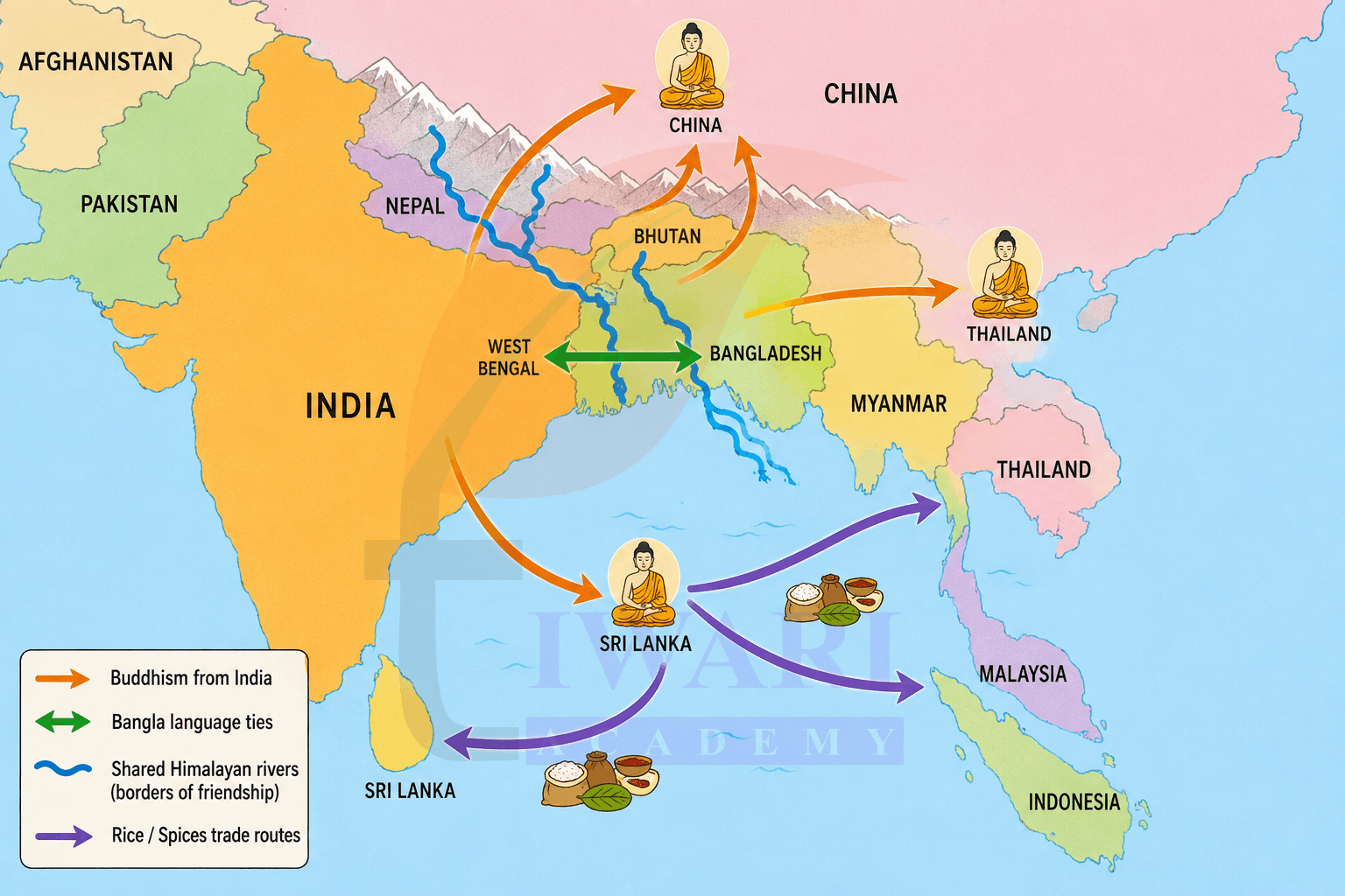
⟶ Imagine and redraw new “borders of friendship” that connect neighbours through rivers, trade routes or cultural zones.
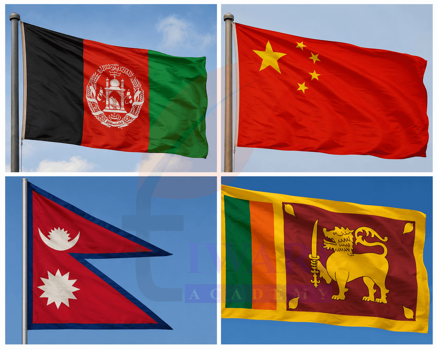
⟶ Collect pictures of the flags of the countries listed in this chapter and write your observations.
Class 7 Social Science Part 2 Chapter 2 Extra Questions for Exam Preparation
Class 7 Social Science Part 2 Chapter 2 Very Short Answer Type Questions.
Very Short Answer Type Questions
1. What is a maritime neighbour?
See AnswerA maritime neighbour is a country connected to another by sea, without needing a shared land border.
2. How long is India’s total land boundary?
See AnswerIndia’s total land boundary stretches over 15,100 km across diverse landscapes.
3. Name India’s immediate maritime neighbours across the water.
See AnswerSri Lanka and the Maldives are India’s immediate maritime neighbours across the water.
4. What is regionalism, as mentioned in the chapter?
See AnswerRegionalism means countries working together for peace, stability and shared progress in a region.
5. Which Chinese monks travelled to India for Buddhist learning?
See AnswerFaxian and Xuanzang were Chinese monks who travelled to India for Buddhist learning.
6. When was Pakistan created, separating from India?
See AnswerPakistan was created in 1947 during the Partition, separating from India.
7. What is the Kartarpur Corridor?
See AnswerIt is a visa-free border crossing allowing Indian pilgrims to visit Gurdwara Darbar Sahib in Pakistan.
8. When was Bangladesh formed?
See AnswerBangladesh was formed in 1971, as the outcome of a war between India and Pakistan.
9. What does India-Nepal’s “open border” policy allow?
See AnswerIt allows citizens to cross freely between India and Nepal without passports or visas.
10. What is Bhutan called by its own inhabitants?
See AnswerBhutan is called “Drukyul”, meaning “Land of the Thunder Dragon”.
11. What organisation was formed in 1985 for regional cooperation in South Asia?
See AnswerSAARC, the South Asian Association for Regional Cooperation, was formed in 1985.
12. What is the Palk Strait?
See AnswerThe Palk Strait is the narrow stretch of sea separating India and Sri Lanka.
13. Name India’s initiative that Maldives is a member of, related to solar energy.
See AnswerThe Maldives is a member of India’s International Solar Alliance for solar energy research.
14. What ancient Sanskrit-named culture flourished in Thailand from the 6th to 11th centuries?
See AnswerThe Dvaravati culture, named after Krishna’s city Dvaraka, flourished in Thailand.
15. What is Oman historically known for trading with the Indus civilisation?
See AnswerOman is known as the “Land of Copper”, traded with the Indus-Sarasvati civilisation.
Class 7 Social Science Part 2 Chapter 2 Short Answer Type Questions.
Short Answer Type Questions
1. Explain India’s position as a maritime nation.
See AnswerIndia is surrounded by sea on three sides with an 11,100 km coastline. Its peninsular shape extends into the Indian Ocean, giving it access to important sea routes connecting Southeast Asia, West Asia and Africa for trade and cooperation.
2. How has Buddhism connected India with her neighbours?
See AnswerBuddhism originated in India and spread to China, Sri Lanka, Bhutan, Thailand and Myanmar through monks and pilgrims. Indian monks like Bodhidharma carried teachings abroad, while foreign monks like Xuanzang visited India, creating lasting spiritual and cultural connections.
3. Describe the India-China border and their trade relationship.
See AnswerIndia and China share a border across Arunachal Pradesh, Sikkim, Uttarakhand, Himachal Pradesh and Ladakh. Trade continues today, with India exporting iron ore and chemicals and importing electronics, though the balance heavily favours China.
4. What tensions and conflicts have shaped India-Pakistan relations?
See AnswerSince the 1947 Partition, India and Pakistan have faced wars in 1948, 1965 and 1971, plus the Kargil War in 1999. Frequent terrorist attacks supported by Pakistan’s army have further prevented normal relations between the two nations.
5. How do India and Bangladesh share environmental responsibilities?
See AnswerIndia and Bangladesh jointly manage the Sundarban National Park, a UNESCO World Heritage Site and the world’s largest mangrove forest, home to the Bengal tiger. It also acts as a natural barrier against cyclones for both countries.
6. What is the significance of the India-Nepal Treaty of 1950?
See AnswerThe 1950 Treaty of Peace and Friendship allows open borders between India and Nepal, enabling free movement of people and goods without passports or visas, along with cooperation in defence and foreign policy matters.
7. How did India help after the 2004 Indian Ocean tsunami?
See AnswerAfter the devastating 2004 tsunami that killed over 200,000 people, India joined Indonesia, Sri Lanka and Thailand to build an early warning system. The Indian Tsunami Early Warning Centre in Hyderabad now helps alert the entire region.
8. Explain the historical connection between Indonesia and India through architecture.
See AnswerThe Borobudur Stupa in Indonesia, built in the 8th-9th centuries CE, reflects deep Buddhist influence from India. Its mandala-shaped design and Hindu-Buddhist name origins (like Suvarnabhumi) show centuries-old cultural and religious exchange between the two nations.
9. What role does Chabahar Port play in India-Iran relations?
See AnswerIndia is helping develop Iran’s Chabahar Port, which gives India better access to Afghanistan and Central Asia. This modern cooperation continues centuries-old ties in trade, energy and transport despite international challenges Iran faces.
10. Why is Oman considered an important strategic partner for India?
See AnswerOman shares maritime boundaries with India and has 5,000-year-old trade ties dating to the Harappan civilisation. Today, it is India’s closest defence partner in the Gulf, hosting joint military exercises with all three Indian armed forces.
Class 7 Social Science Part 2 Chapter 2 Long Answer Type Questions.
Long Answer Type Questions
1. Explain the concept of “maritime neighbours” and list the countries considered India’s maritime neighbours, along with their significance.
See AnswerA maritime neighbour is a country connected to another through a shared sea or ocean, even without a direct land border. Since India has a long coastline of about 11,100 km and a peninsular shape extending into the Indian Ocean, it has several maritime neighbours beyond Sri Lanka and the Maldives, including Iran, Oman, Thailand, Malaysia, Singapore and Indonesia. These nations are connected to India through centuries of trade, cultural exchange and shared use of important sea routes. This wider maritime neighbourhood has helped India build strategic partnerships, disaster relief cooperation and economic ties across the Indian Ocean region, proving that neighbourhood is not just about geography but about historical and functional connections.
2. Describe the complex relationship between India and Pakistan, covering both conflicts and attempts at peace.
See AnswerIndia and Pakistan share one of the most complicated relationships in South Asia. Before the 1947 Partition, Pakistan was part of India, but it was founded on a religious basis. Since Partition, several wars (1948, 1965, 1971) and conflicts like the Kargil War (1999) have created ongoing tension, worsened by terrorist attacks against India supported by the Pakistani army. However, the relationship also includes attempts at peace, such as trade periods and pilgrimage routes for Hindus and Sikhs. The Kartarpur Corridor, opened in 2019, is a notable example, allowing visa-free access for Indian pilgrims to visit Gurdwara Darbar Sahib, the final resting place of Guru Nanak Dev, showing that shared heritage can create pathways for cooperation despite political tensions.
3. Discuss how India has helped smaller neighbouring countries, with examples.
See AnswerIndia has extended support to smaller neighbours in multiple ways. In Afghanistan, India supported education, healthcare and infrastructure development, including building the Afghan Parliament and the Zaranj-Delaram highway. In the Maldives, India provided rapid disaster relief during the 2004 tsunami, the 2014 water crisis in Malé, and the COVID-19 pandemic, earning its reputation as the region’s “trusted first responder”. In Myanmar, India helped restore the earthquake-damaged Ananda temple in Bagan and gifted a Buddha statue replica to the Shwedagon Pagoda. India also supports regional disaster preparedness through the Indian Tsunami Early Warning Centre, benefiting Indonesia, Sri Lanka and Thailand. These examples show India’s role as a responsible regional power committed to supporting her neighbours in times of need.
4. Explain how ancient trade routes and the spread of religion shaped India’s relationship with Southeast Asian countries like Thailand, Malaysia and Indonesia.
See AnswerFrom a few centuries BCE, Indian traders sailed to Southeast Asia in search of gold, giving rise to names like “Suvarnabhumi” (golden land) for the region. This maritime trade carried not just goods but also religion and culture. In Thailand, the Dvaravati culture and Ayutthaya Kingdom took their names from Indian cities like Dvaraka and Ayodhya, while Hindu myths like samudra manthana are depicted even today, such as at Bangkok airport. In Malaysia, Hindu-Buddhist influences introduced the Brahmi-based script and Indian workers later migrated for rubber plantation labour, leaving 9% of the population of Indian origin today. In Indonesia, the shared legacy includes the Borobudur Stupa, a mandala-shaped Buddhist monument reflecting deep Indian architectural and spiritual influence. Together, these examples show how peaceful trade and religious exchange, rather than conquest, spread Indian civilisation across Southeast Asia.
5. How do shared environmental and geographic challenges create opportunities for cooperation between India and her neighbours? Give examples.
See AnswerShared environmental and geographic challenges have often become platforms for cooperation between India and her neighbours rather than sources of conflict. With Bangladesh, India jointly manages the Sundarban National Park, a UNESCO World Heritage mangrove forest that acts as a cyclone barrier, even though climate change and rising sea levels threaten the region. With the Maldives, India collaborates through the International Solar Alliance to address the island nation’s vulnerability to rising sea levels. Following the devastating 2004 Indian Ocean tsunami, India worked with Indonesia, Sri Lanka and Thailand to establish a tsunami early warning system centred in Hyderabad, protecting the entire region. Similarly, with Oman, India cooperates on Indian Ocean maritime security. These examples demonstrate that natural disasters, climate vulnerability and shared water bodies push neighbouring countries toward mutual support and long-term regional partnerships.
Frequently Asked Questions
What is Chapter 2 of Class 7 Social Science Part 2 (2026-27) about?
Chapter 2, India and Her Neighbours, is part of the new NCERT textbook “Exploring Society: India and Beyond”, Part 2, for the 2026-27 session. It explores India’s relationships with land-based neighbours like China, Pakistan, Bangladesh, Nepal, Bhutan, Myanmar, and Afghanistan, as well as maritime neighbours like Sri Lanka, the Maldives, Thailand, Malaysia, Singapore, Indonesia, Iran and Oman, covering their shared history, culture, trade and challenges.
Does Class 7 Social Science Part 2 Chapter 2 only talk about countries sharing a land border with India?
No. A key learning point of this chapter is that “neighbour” isn’t limited to land borders. Since India is surrounded by sea on three sides with an 11,100 km coastline, the chapter introduces the concept of “maritime neighbours” like Sri Lanka, Maldives, Thailand, Malaysia, Singapore, Indonesia, Iran and Oman, who are connected to India through historical sea routes and trade.
Why does Class 7 Social Science Part 2 Chapter 2 discuss ancient trade routes and Buddhism so much?
The chapter emphasises that India’s relationships with her neighbours aren’t only political or modern; they have deep historical roots. Ancient routes like the Uttarapatha and maritime spice routes carried goods, ideas and religions like Buddhism and Hinduism to Central Asia, China, Sri Lanka and Southeast Asia, which is why place names, temples and traditions in these countries still reflect Indian influence today.
What is SAARC and why is it important in Class 7 Social Science Part 2 Chapter 2?
SAARC (South Asian Association for Regional Cooperation) is a regional organisation formed in 1985 with eight member nations: Afghanistan, Bangladesh, Bhutan, India, the Maldives, Nepal, Pakistan and Sri Lanka. The chapter highlights it as an example of regional cooperation aimed at promoting mutual interests in science, education and economic progress, though political tensions among members have sometimes disrupted its functioning.
Why does Class 7 Social Science Part 2 Chapter 2 mention the Kartarpur Corridor and Chabahar Port?
These are highlighted as real-world examples of connectivity and cooperation despite complex relationships. The Kartarpur Corridor (with Pakistan) allows visa-free pilgrimage access to a sacred Sikh shrine, while the Chabahar Port (with Iran) gives India better trade access to Afghanistan and Central Asia. Both show how practical cooperation can exist even amid geopolitical challenges.
How does Class 7 Social Science Part 2 Chapter 2 address sensitive topics like India-Pakistan or India-China relations?
The chapter presents these relationships factually and age-appropriately, acknowledging historical conflicts (such as the 1947 Partition, wars of 1948, 1965, 1971 and the Kargil War with Pakistan or border tensions with China) while also highlighting cultural ties, trade and efforts toward peace and dialogue, encouraging students to understand these relationships in a balanced, non-simplistic way.
Is Class 7 Social Science Part 2 Chapter 2 useful for understanding current affairs and India’s foreign policy?
Yes, this chapter builds a foundational understanding of India’s geopolitical position, regional cooperation efforts and the historical basis of India’s relationships with her neighbours. It helps students connect classroom learning to real-world events, such as disaster relief efforts, trade partnerships and regional connectivity projects, which are relevant to current affairs and future civics or political science studies.